Glacial Lake Outburst Floods (GLOFs) in the Cordillera Huayhuash, Peru: Historic Events and Current Susceptibility


1
Department of Physical Geography and Geoecology, Faculty of Science, Charles University, 128 43 Prague, Czechia
2
Department of Applied Geoinformatics and Cartography, Faculty of Science, Charles University, 128 43 Prague, Czechia
3
Geography and Environmental Science, University of Dundee, Dundee DD1 4HN, UK
4
UNESCO Centre for Water Law, Policy and Science, University of Dundee, Dundee DD1 4HN, UK
5
Global Change Research Institute, The Czech Academy of Sciences, 603 00 Brno, Czechia
6
Institute of Geography and Regional Science, University of Graz, 8010 Graz, Austria
*
Authors to whom correspondence should be addressed.
†
Until August 2020 at Global Change Research Institute, The Czech Academy of Sciences, 603 00 Brno, Czechia.
Water 2020, 12(10), 2664; https://doi.org/10.3390/w12102664
Submission received: 21 August 2020
/
Revised: 18 September 2020
/
Accepted: 19 September 2020
/
Published: 23 September 2020
(This article belongs to the Section Hydrology)
Abstract
:The aim of this paper is to create a glacial lake inventory for the Cordillera Huayhuash in Peru and to evaluate the susceptibility of lakes to the generation of glacial lake outburst floods (GLOFs). Using high-resolution satellite images, we undertook qualitative and quantitative analysis of lake type, characteristics and distribution, and placed our findings within the context of existing Peru-wide lake inventories. We also mapped and analyzed past GLOFs, revealing a total of 10 GLOFs and 4 ambiguous events, most of which have not been reported before. We found that past GLOFs usually occurred as a result of moraine dam breach during the proglacial stage of lake evolution. Further, we used our lake inventory to evaluate GLOF susceptibility of all lakes larger than 20,000 m2. Of 46 evaluated lakes, only two lakes (Lake Tsacra and Lake W014) are currently susceptible to generating a GLOF, which would most likely be through dam overtopping resulting from a flood originating in smaller lakes located upstream. The future perspectives of lake evolution and implications for GLOF hazard management are discussed in light of the post-Little Ice Age glacier ice loss as well as in the context of extensive related research undertaken in the nearby Cordillera Blanca.
Keywords:
glacial lakes; GLOFs; GLOF susceptibility; moraine-dammed lakes; Cordillera Huayhuash; Andes; Peru1. Introduction
The vast majority of glacierized high mountains have experienced glacier shrinkage in past decades (e.g., [1,2,3]). Lakes commonly develop in front or on top of receding or thinning glaciers (e.g., [4,5]), and these lakes can represent a threat of glacial lake outburst floods (GLOFs), i.e., a sudden release of water retained within a glacial lake regardless of trigger, failure mechanism, or glacial lake sub-type (e.g., [6,7]). Research into GLOFs has grown exponentially in recent years, with increased attention paid to low-income, densely populated mountain regions such as those located in high-mountain Asia (Nepal, India) and the Tropical Andes (Peru, Bolivia) [8].
There is a decades-long tradition of research on glaciers and glacier-related hazard and risks in the Peruvian Tropical Andes (e.g., [9]). More recently, [10] highlighted the rapid shrinkage of tropical Andean glaciers since the Little Ice Age and [11] correlated together dated periods of increased glaciation (deglaciation) with enhanced clastic sediment flux (decline) in this region. Patterns of glacier recession were described by [12], in accordance with an estimated average air temperature trend of +0.26 °C per decade. A review of climate change in relation to glacier mass balance was prepared by [13], highlighting the delayed response of glaciers to changing conditions. Temperature and precipitation changes do not completely explain the strong glacier retreat during the past few decades. As [13] described, the relationship between glacier behavior and climate change is very complicated. It also involves glacier characteristics, local morphological conditions (slope, aspect, etc.), local and regional climate and large-scale climate settings.
Societies settled in the tropical Andes have been impacted by glacier-related natural catastrophes for centuries, with such events dated back to the early 18th Century in some regions, such as the Peruvian Cordillera Blanca [14]. Notable examples include the 1970 earthquake-triggered ice- and rock-avalanche from Huascarán, which destroyed the town of Yungay [15,16], and the 1941 Palcacocha GLOF where sediment-laden floodwaters destroyed a considerable part of the city of Huaráz. This latter event is among the most catastrophic and the best-researched natural dam failures ever documented [17,18,19,20,21]. A more recent example is the 2010 GLOF from Lake 513 [22,23,24]. A total of 28 GLOFs from moraine-dammed lakes were documented across the Cordillera Blanca using a set of geomorphic diagnostic features [25].
Only limited research attention has been paid to glacier change, geomorphology and geohazards in the Cordillera Huayhuash, despite this mountain range being located only ~50 km SE from the well-studied Cordillera Blanca (see Section 1.1). Among the few existing regional studies, [26] undertook a comprehensive assessment of the geochronology of Quaternary glaciation in the C. Huayhuash, and [27] investigated the formation of a landslide-dammed lake in the Carhuacocha valley. However, no systematic attention has been paid to glacial lake development, evidence for past GLOFs, or current GLOF susceptibility in the C. Huayhuash. To fill this gap, we aim (i) to generate a glacial lake inventory for the C. Huayhuash, and to use that inventory as the basis for (ii) identifying and describing previous GLOFs in the region, and (iii) assessing the susceptibility of existing lakes to the generation of GLOFs.
1.1. Study Area
The Cordillera Huayhuash is located about 200 km north of Peru’s capital, Lima, and about 50 km south east from the Cordillera Blanca (10.3° S, 76.9° W; Figure 1); indeed, the Cordillera Huayhuash may be interpreted as the southern continuation of the Cordillera Blanca [28]. It is the second highest mountain range in Peru with Nevado Yerupajá reaching 6617 m a.s.l. Its main, largely glacierized spine stretches 25 km in a roughly north-south direction with two lateral ridges, each extending about 10 km to the west. The geological setting of the area is characterized by Cenozoic volcanic rocks (30–15 and 6 Ma) underlain by Cretaceous carbonates and quartzites and the Late Cretaceous Coastal Batholith, with a series of Late Miocene granitic plutons [28]. The Cordillera Huayhuash has been shaped by Quaternary glacial and fluvial erosion forming valleys perpendicular to the main ridge.
The western side of the range is drained by the Río Pativilca into the Pacific Ocean, whereas the tributaries of Río Marañón drain the eastern side (part of the Amazon Basin). The Cordillera Huayhuash experiences a strong east-west precipitation gradient with significantly more humid conditions on the eastern side [26]. About 75% of the annual rainfall (that varies from 500 to 2000 mm per year) [29] occurs during the rainy season from November to April. Researchers in [26] assumed that the Lateglacial paleoglaciers descended as low as 4000 m a.s.l. and identified several stages of advances: ~22–20 ka, ~14–13 ka, ~10–9 ka. During these stages, numerous over-deepenings were carved and large moraines were produced [26]. The last significant glacier advance occurred ~0.3 ka (the Little Ice Age; LIA). Since the end of the LIA, glaciers have been retreating. The 35% reduction in glaciated area from 85 km2 in 1970 [30] to only 55 km2 in 2007 [31] was accompanied by an upward shift of the ELA (equilibrium line altitude) reported by [32].
Glacier retreat has been accompanied by the formation and evolution of glacial lakes with the potential to generate GLOFs. Five GLOFs have previously been mentioned in the literature to have occurred in the Cordillera Huayhuash: the 1932 GLOF from Lake Solteracocha, repeated GLOFs from Lake Sarapococha (in the 1940s or earlier and in 1981), the 1941 GLOF from Lake Rurigallay (also named Yerush or Santa Rosa), and a GLOF from Lake Juraucocha (also in the 1940s or earlier) [7,9,14,33]. In their global review of GLOF events, [19] do not include GLOFs from the Cordillera Huayhuash. The GLOF inventory of [7] mentions six GLOFs from moraine-dammed lakes in the Cordillera Huayhuash, but provide no details about the locations, so these events cannot be confirmed and are incompletely documented (see Section 2.2 and Section 3.2).
2. Materials and Methods
2.1. Lake Inventory
A lake inventory for the Cordillera Huayhuash was compiled based on the 2017 high-resolution, cloud-free satellite images available in Google Earth Pro (CNES/Astrium/Airbus). These images are characterized by higher resolution compared to other freely available sources such as Landsat ETM+ or ASTER (Advanced Spaceborne Thermal Emission and Reflection Radiometer), and this approach has been successfully employed in previous studies of GLOFs in the Cordillera Blanca [34]. Lakes were mapped by visual interpretation of these images without the digital elevation model (DEM). Each lake was assigned a unique ID and its polygon was manually delimited along the lake shoreline, from which lake area was measured. Lakes ≥200 m2 were included in the final inventory. In addition, a series of qualitative observations and quantitative data were collated for each lake. These included: coordinates, lake type (moraine-dammed, bedrock-dammed, combined dam, relict; see Figure 2), lake axis orientation (16 directions), presence of surface meltwater outflow (yes, no), proglacial (i.e., ice-contact; yes, no), presence of glaciers in its drainage area (yes, no), and lake level elevation (continuous value).
The 2017 optical satellite images available in Google Earth have a resolution appropriate and sufficient for region-wide lake mapping; however, the resolution of the available DEM is limiting and results in some lake polygons being located partly on slopes. The elevation difference of the highest and lowest points of lake polygons ranged by up to 180 m in extreme cases (with the average difference of 13.8 m). The lake polygons are often deformed by adjacent steep slopes, rock walls or icefalls when projected onto this DEM. We calculated lake level elevation as an average of minimum and maximum DEM value within the lake polygon. In addition, some of the moraine dams are not morphologically recognizable in the DEM, resulting in the need for subjective assessment from alternative sources (e.g., field images).
2.2. Inventory of Past GLOFs
In this study, we focus on GLOFs that have occurred since the Little Ice Age, some 0.3 ka ago [26]. To create the inventory of past GLOFs in the Cordillera Huayhuash, we integrated:
- Documentary data sources from the archive of the Autoridad Nacional del Agua (ANA) located in Huaráz, Peru, and the archive of the University of Salzburg, Austria;
- The analysis of high-resolution, remotely-sensed images available via Google Earth Digital Globe (Maxar technologies, CNES/Airbus images) for the period 2003/2010–2019 [35], and Landsat images (15 m/30 m/90 m resolution) for the period 1972–2020, which were accessed through Google Earth Engine [36];
- Field survey in June 2018 and July 2019 (reconnaissance, geomorphological mapping).
Available literature from the archives (e.g., [9,14,33]) as well as recent studies (e.g., [7,19]) provide only sparse information on past GLOFs in the Cordillera Huayhuash, mostly with missing locations or ambiguous names. Therefore, we have applied the methodology of [37] to identify geomorphological features that are diagnostic of GLOFs by employing remotely sensed image analysis and field mapping. This methodology has been successfully employed by [25] in the Cordillera Blanca. Focusing on moraine dam failure-induced GLOFs, these include: (i) breached moraine dam (clear incision through the moraine dam body; not applicable for rare piping- and overtopping-induced floods); (ii) outwash fan (located downstream from failed dam); (iii) permanent lake level drawdown (visible exposure of lake sediments indicating lake level lowering; for examples see Figure 3). In addition, downstream geomorphological imprints (erosion and accumulation landforms) were also considered in cases of GLOFs associated with dam overtopping (e.g., GLOFs from bedrock-dammed lakes), although these landforms might be ephemeral or related to hydrometeorologically-induced floods. Such events were classified as ‘ambiguous’ in the inventory.
2.3. Assessment of the Susceptibility of Glacial Lakes to Outburst Floods
Numerous methods exist in the literature for assessing GLOF susceptibility, considering different sets of GLOF indicators (see the overview of [38]). The assessment of GLOF susceptibility carried out in this study follows the method developed by [39] for the Cordillera Blanca. Five GLOF scenarios are distinguished, based on the analysis of the past GLOF events in the region (Table 1). A matrix of three triggers (slope movement into the lake, flood wave from the lake located upstream, strong earthquake) and two mechanisms (dam failure, dam overtopping) shows possible combinations considered in the assessment procedure. While earthquake-induced dam overtopping is not plausible, a total of five scenarios (Scenarios 1–5) are assessed (see Table 1).
GLOF susceptibility is calculated for each of the scenarios separately and combines decision trees with simple equations. The resulting susceptibility to each scenario ranges from 0 (not susceptible) to 1 (susceptible) and susceptibility classes differ for individual scenarios, reflecting pre-GLOF susceptibility assessment of lakes which produced GLOFs in the past (see Table 1 and [39] for methodological details). A set of 17 characteristics are incorporated into the assessment procedure. These are:
- Characteristics of the dam (type, width and height, dam freeboard, maximum slope of the distal face of the dam, presence of piping, piping gradient, remedial works),
- Characteristics of the lake (area, perimeter, maximum width), and
- Characteristics of lake surroundings (width of calving front, distance and mean slope between lake and glacier, mean slope of the lowermost 500 m of the glacier tongue, maximum slope angle of the moraine surrounding the lake, mean slope of the lake surroundings).
In Scenario 1 (dam overtopping due to slope movement into the lake), three possible sources of rapid slope movements are considered: ice avalanches, calving of the ice front, and landslides in moraines surrounding the lake. If the displacement wave produced by any of these is not stopped by the sufficient dam freeboard, the lake dam is overtopped. The overtopping of the dam of the assessed lake may be also triggered by a flood wave from a lake located upstream, if present (Scenario 2). Either the volume of an upstream lake must exceed the retention potential of the assessed lake, or, if the assessed lake has a surface outflow, any upstream lake must exceed the specific critical area to produce a flood wave able to cause the downstream lake to overflow. When assessing whether the dam will be overtopped or whether dam overtopping will develop into a dam failure, one has take into account dam erodibility and remedial works, if implemented (Scenario 3—dam failure due to slope movement into the lake); or Scenario 4—dam failure due to flood wave from an upstream lake). In Scenario 5 (dam failure due to strong earthquake), the geometry of the dam and piping through the dam enter the assessment procedure.
For full details on the GLOF susceptibility assessment methodology, readers are referred to [39]. Due to the data demand, we assessed GLOF susceptibility of lakes larger than 20,000 m2 (46 lakes).
3. Results
3.1. Lake Inventory
We have mapped 270 lakes (a total area 6.31 km2), of which 167 (total area 3.16 km2) are located in the western part of the study area, and 103 (total area 3.15 km2) are located in the eastern side (see Table 2; Figure 4). A total of 137 lakes are classified as moraine-dammed, 92 as bedrock-dammed, 37 are relict, 3 lakes have combined dam (bedrock + moraine) and one lake is dammed by moraine in combination with debris flow deposition. Basic characteristics of mapped lakes with regard to area, elevation, presence/absence of surface outflow, glaciers in the catchment, and direct contact with glacier ice are shown in Table 3; for the lake axis orientation, see Supplementary Materials Table S1.
Comparison of the two most common lake types shows that bedrock-dammed lakes were formed in higher altitudes and are more than two times smaller on average than moraine-dammed lakes. However, no relation between lake area and lake level elevation was revealed (R2 = 0.164). The catchments of the bedrock-dammed lakes are mostly deglaciated whereas most of the moraine-dammed lakes host glaciers in their catchments.
The comparison of the western and eastern sides of the Cordillera Huayhuash show that the much larger western part (77% of the area) hosts only 62% of lakes which are mostly located at higher elevations (75% of them at 4751–4950 m a.s.l.); the average altitude of the lakes is about 167 m higher than on the eastern side (see Table 3). The general elevational distribution of lakes shows two peaks at 4551–4600 m a.s.l. (typical for the eastern side) and 4751–4800 m a.s.l. (typical for the western side) and the total lake areas differ by only 0.006 km2 between the eastern and western sides. The axial orientation of the lakes is mostly related to the orientation of their parent glaciers, which is controlled by their location on the main ridges. The majority of the 10 proglacial lakes do not exceed 4000 m2 in area, with only two cases exceeding 10,000 m2 (W007, W014).
3.2. Past GLOFs
In total, we found geomorphological evidence of ten GLOFs originating from nine lakes in the Cordillera Huayhuash (with one lake generating two GLOFs) and four suspicious or ambiguous events, which are likely to have been GLOFs (see Table 4; Figure S1). Five of the GLOFs were previously mentioned in the literature, but the remaining events were not. Eleven GLOFs or suspected GLOFs occurred in the western (Pacific) side of the study area while the remaining three events (Gangrajanca and Chaclan and E087) occurred on the eastern side of the range divide. The majority of GLOF-producing lakes have moraine dams; one GLOF-producing lake is bedrock-dammed (W023) and one has a combined dam (W085). Seven of the identified GLOFs were associated with breaching of moraine dams, while the remaining events were, according to the observed GLOF diagnostic features and the absence of a clearly breached dam, more likely associated with dam overtopping (bedrock-dammed lake W023, moraine-dammed lakes Chaclan, Caramarca, E087, W097, lake with combined dam W085, and the second GLOF from Lake Sarapococha). All GLOF-producing lakes still exist (in April 2020).
Little is known about the preconditions and triggers of these GLOFs. Historical field images from Austrian–German expeditions carried out in the 1930s, as well as satellite remote sensing imagery, nevertheless reveal some details of these events. Strikingly, most of the current glacier-detached, large moraine-dammed lakes were proglacial at the time of the GLOF (often proglacial in the first post-GLOF image available). For instance, Lake Solteracocha was proglacial several (tens of) years after dam failure (see Figure 5).
3.3. GLOF Susceptibility Assessment
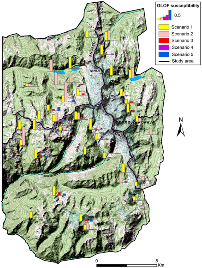
The vast majority of lakes of the Cordillera Huayhuash have low susceptibility to generating GLOFs (Figure 6; Table S2). Table S2 further shows that the most frequently expected GLOF scenario in the Cordillera Huayhuash is the dam overtopping due to rapid slope movement into the lake (Scenario 1), followed by the scenario of dam overtopping due to flood wave impact from a lake located upstream (Scenario 2). The susceptibilities of other scenarios rarely exceeded the threshold of negligible values. Out of the 46 evaluated lakes, only two exceeded high susceptibility thresholds, both in Scenario 2. These are Lake Tsacra (W007) and Lake W014. The width of the calving front exceeds the lake width in both cases, which is the main factor increasing susceptibility to GLOF (together with surface outflow, i.e., 0 m dam freeboard). Five lakes were found to have medium GLOF susceptibility for Scenario 1 and four other lakes for Scenario 2. Dam failures (Scenarios 3, 4 and 5) appear unlikely in the Cordillera Huayhuash, considering the fact that the majority of steep-sloped moraine dams that retain large lakes have already failed (see Section 3.2 and Section 4.2).
4. Discussion
4.1. Comparison with Existing Peru-Wide Lake Inventories and Future Perspectives
In 2007, there was a total of 106 lakes in the Cordillera Huayhuash (according to [31]). More recent data published by [41] indicate that, in 2015, there were 111 lakes. However, these earlier studies did not state a minimum area limit for inclusion of any given lake in the inventory. In our inventory, based on the 2017 high-resolution satellite images, we have mapped 270 lakes. This large discrepancy in the number of lakes could be explained because of the areal threshold used and the increasing quality and availability of high-resolution satellite images, allowing the mapping of lakes larger than 200 m2. According to the 2007 Lake Inventory for Cordillera Huayhuash [31], lakes covered a total area of 6.3 km2. Our inventory yields the same total extent, despite the identification of a greater number of lakes (270 compared to 106). This illustrates that the smallest lakes, which are included in our database, do not change the total area extent greatly.
The glacier extent in the Cordillera Huayhuash declined by 35% between 1970 and 2000 [31], leading to the formation of new glacial lakes. As this trend of glacier retreat is expected to continue [42] revealed 11 locations that could host new lakes in the future as subglacial overdeepenings are revealed (with total area of 0.5 km2 and volume of 6 mil·m3), while [43] identified 15 locations that could host new lakes in the future (approx. total area of 0.6 km2 and volume of 7.7 mil·m3). If we compare Cordillera Huayhuash with other Peruvian mountain ranges, the future possible area of new lakes created is rather similar (e.g., Cordillera Raura, Huaytapallana, Vilcabamba, Ampato, Carabaya, Apolobamba and Central), while the Cordillera Vilcanota is likely to develop a greater number of new lakes, and even more than the well-studied Cordillera Blanca (after [43]).
4.2. Timing of GLOF Occurrence and GLOF Hazard Implications
All mapped GLOF-producing lakes are the first or second generation of lakes in terms of distance from glacier termini, suggesting that: (i) these lakes are most likely not older than a few hundred years (for dating of moraines see [26]); (ii) GLOF response time (i.e., a period between the lake formation and a GLOF) likely did not exceed several tens of years (for more details on this concept see [7]), which is in line with recent findings from the Cordillera Blanca [44]. Approximating the timing of past GLOFs is complicated because of a lack of data before the advent of satellite remote sensing. While inhabitants of settled regions can preserve knowledge about past disasters for centuries (see the example of past GLOFs in the Cordillera Blanca in [25]), this is not the case for the remote Cordillera Huayhuash. Solteracocha moraine dam is known to have failed on the 14th March 1932, Rurigallay on the 20th April 1941, and Sarapacocha moraine dam in February 1981. Ref. [9] mention two GLOFs from lakes Juraucocha and Sarapococha, which therefore also occurred in the 1940s or earlier (details on timing are not given). All GLOFs with known month of occurrence occurred during the wet season (from November to April), suggesting a common trigger (see below).
The limited information about GLOF timing in the Cordillera Huayhuash (Table 4) shows that major and extreme moraine dam failure-induced GLOFs (Solteracocha, Sarapococha, Rurigallay) occurred in the first half of the 20th Century, which is in line with the observations from the Cordillera Blanca where the peak frequency of GLOFs from moraine-dammed lakes was observed from late 1930s to early 1950s [44]. Increased occurrence of GLOFs during the wet season (see Table 4) explains why many of these events remained unnoticed, because mountain pastures are only used during the dry season (which is true also of tourism). The ratio of GLOF-producing moraine-dammed lakes (n = 11) to existing moraine-dammed lakes (n = 137) is 0.080. This value is comparable to the Cordillera Blanca (0.074; [25]) and much higher compared to other mountain ranges across the world, e.g., Himalayas where only tens of GLOFs were documented while several thousands of lakes are present [45]. This can be explained by more advanced stages of deglaciation (and associated spatio-temporal patterns of hazardous processes) in the tropical mountain ranges [7,44]. Considering lessons learned from the nearby Cordillera Blanca [44], we suggest that the magnitude of potential GLOFs from currently forming and future bedrock-dammed lakes will likely be lower compared to extreme moraine dam failure-induced GLOFs in the first half of the 20th Century.
4.3. Uncertainties and Limitations of the GLOF Susceptibility Assessment Method
We used high resolution satellite images for lake mapping, considering all lakes larger 200 m2. The manual delimitation of lake polygons might introduce inaccuracies, but we found these rather negligible considering overall lake area, seasonal and intra-seasonal lake level (and area) fluctuations, and the purpose of this mapping. Moreover, the lake size does not influence assessment of lake susceptibility to generation of GLOF. Another source of uncertainty is the resolution and quality of the Google Earth Digital Elevation Model (DEM), which was used as a primary DEM for measuring some characteristics such as lake level elevation or dam geometry. To explore these possible inaccuracies, a large amount of field data are needed. Future work could focus on evaluation of remote sensing-based data through field observations.
GLOF-susceptible lakes are frequently identified based on their similarity with lakes, which have produced GLOFs in the past. This is also the case of the method employed by [39], which we used in this study. The GLOF assessment method by [39] was originally designed for the Cordillera Blanca and the thresholds are based on previous GLOFs in that region. Our analyses show that previous GLOFs in the Cordillera Huayhuash are comparable to those of the Cordillera Blanca [18,25] in terms of GLOF mechanisms and possible triggers, and so that the use of this methodology is appropriate. However, this method could possibly omit another GLOF triggers that were not documented previously from this region (e.g., buried ice melting-induced moraine dam failure) and, thus, are not reflected in the method.
As for the limitations of the GLOF susceptibility assessment method used, it is important to mention that: (i) the GLOF susceptibility method used here does not consider possible GLOF magnitude, however, we have only assessed GLOF susceptibility of large lakes; (ii) some of the characteristics need to be measured or assigned manually, based on the visual interpretation of satellite images (qualitative characteristics such as occurrence of piping throughout the dam), which may introduce subjective elements into the assessment. To avoid methodological discrepancies among different assessors, all these measurements and image interpretations were undertaken by a single person such that the results are at least self-consistent.
5. Conclusions
A total of 270 lakes in the Cordillera Huayhuash were identified, mapped and described by quantitative and qualitative attributes. This number is much higher compared to earlier existing lake inventories, despite the total area (6.3 km2) being comparable. The largest group of lakes was classified as moraine-dammed lakes (137 lakes) followed by bedrock-dammed (92 lakes). The relict or combined lakes are rare. Spatial analysis revealed that bedrock-dammed lakes are located in higher elevations and are on average smaller compared to moraine-dammed lakes. Nevertheless, the statistical analysis did not show any relation between individual lake areas and their respective elevations.
We found geomorphological evidence of ten GLOF events from nine lakes and four other possible events. Only five GLOFs were mentioned in the literature previously. The majority of GLOF-producing lakes are moraine-dammed and outburst mainly occurred through the breaching of moraine dam rather than by dam overtopping. We have only limited information about triggers of these GLOFs, but most of those lakes were likely proglacial (ice-contact) during the time of the GLOF. The proglacial stage of the lake evolution yields higher susceptibility to glacier-calving triggered GLOFs, as has been demonstrated previously in the nearby Cordillera Blanca, for example.
The majority of glacial lakes in the Cordillera Huayhuash have rather low susceptibility to generating GLOFs. We evaluated 46 lakes larger than 20,000 m2 and only two of them exceeded the high GLOF susceptibility threshold (both in Scenario 2, i.e., the dam overtopping following a flood wave originating in a lake situated upstream). These are lake Tsacra and Unnamed Lake W014, both located downstream of possibly unstable smaller lakes. Five lakes have medium GLOF susceptibility for Scenario 1 (i.e., dam overtopping due to a slope movement into the lake) and four other lakes have medium GLOF susceptibility for Scenario 2. This implies that lake dams in the Cordillera Huayhuash have already stabilized or that unstable dams have already failed. Based on these findings, we expect that possible future GLOFs could more likely result from dam overtopping.
Supplementary Materials
The following are available online at https://www.mdpi.com/2073-4441/12/10/2664/s1, Figure S1: detected GLOFs and ambiguous events, Table S1: lake axis orientation of the 270 lakes of the Cordillera Huayhuash, Table S2: GLOF susceptibility of lakes in the Cordillera Huayhuash.
Author Contributions
Conceptualization, J.B. and V.V.; methodology, A.E. and V.V.; field survey, A.E.; analysis, J.B., A.E. and S.J.C.; writing–original draft preparation J.B.; writing–review and editing S.J.C., A.E., V.V.; visualization, E.Š.; supervision, V.V.; funding acquisition, V.V. and A.E. All authors have read and agree to the published version of the manuscript.
Funding
This work and funds to cover publication costs were supported by Inter-Excellence programme of the Ministry of Education, Youth and Sports of the Czech Republic, INTER-VECTOR project LTV19010, and by the Ministry of Education, Youth and Sports of the Czech Republic within the National Sustainability Programme I (NPU I), grant number LO1415. AE was partly supported by the Supporting Perspective Human Resources Programme of the Czech Academy of Sciences, project “Dynamics and spatiotemporal patterns of glacial lakes evolution and their implications for risk management and adaptation in recently deglaciated areas”. AE is a member of the RCUK-CONICYT (Research Council UK and National Commission for Scientific Research and Technology) Glacial Lakes of Peru (GLOP) project.
Acknowledgments
We thank the anonymous reviewers and editors who helped improve the paper.
Conflicts of Interest
The authors declare no conflict of interest.
References
- Zemp, M.; Huss, M.; Thibert, E.; Eckert, N.; McNabb, R.; Huber, J.; Barandun, M.; Machguth, H.; Nussbaumer, S.U.; Gärtner-Roer, I.; et al. Global glacier mass changes and their contributions to sea-level rise from 1961 to 2016. Nature 2019, 568, 382–386. [Google Scholar] [CrossRef]
- Mancini, D.; Lane, S.N. Changes in sediment connectivity following glacial debuttressing in an Alpine valley system. Geomorphology 2020, 352, 106987. [Google Scholar] [CrossRef]
- Bulege-Gutiérrez, W.; Custodio, M. Climate change and glacier retreat in the Huaytapallana Mountain Range, Peru. Tecnol. Cienc. Agua 2020, 11, 229–261. [Google Scholar] [CrossRef] [Green Version]
- Cook, S.J.; Quincey, D.J. Estimating the volume of Alpine glacial lakes. Earth Surf. Dyn. 2015, 3, 559–575. [Google Scholar] [CrossRef] [Green Version]
- King, O.; Dehecq, A.; Quincey, D.; Carrivick, J. Contrasting geometric and dynamic evolution of lake and land-terminating glaciers in the central Himalaya. Glob. Planet. Chang. 2018, 167, 46–60. [Google Scholar] [CrossRef]
- Evans, S.G.; Clague, J.J. Recent climatic change and catastrophic geomorphic processes in mountain environments. Geomorphology 1994, 10, 107–128. [Google Scholar] [CrossRef]
- Harrison, S.; Kargel, J.S.; Huggel, C.; Reynolds, J.; Shugar, D.H.; Betts, R.A.; Emmer, A.; Glasser, N.; Haritashya, U.K.; Klimeš, J.; et al. Climate change and the global pattern of moraine-dammed glacial lake outburst floods. Cryosphere 2018, 12, 1195–1209. [Google Scholar] [CrossRef] [Green Version]
- Emmer, A. GLOFs in the WOS: Bibliometrics, geographies and global trends of research on glacial lake outburst floods (Web of Science, 1979–2016). Nat. Hazards Earth Syst. Sci. 2018, 18, 813–827. [Google Scholar] [CrossRef] [Green Version]
- Kinzl, H.; Schneider, E.; Awerzger, A. Cordillera Huayhuash, Perú—Ein Bildwerk über ein Tropisches Hochgebirge; Verlag Tiroler Graphik: Innsbruck, Austria, 1954; p. 42. [Google Scholar]
- Vuille, M.; Francou, B.; Wagon, P.; Juen, I.; Kaser, G.; Mark, B.G.; Bradley, R.S. Climate change and tropical Andean glaciers: Past, present and future. Earth-Sci. Rev. 2008, 89, 79–96. [Google Scholar] [CrossRef] [Green Version]
- Rodbell, D.T.; Seltzer, G.O.; Mark, B.G.; Smith, J.A.; Abbott, M.A. Clastic sediment flux to tropical Andean lakes: Records of glaciation and soil erosion. Quat. Sci. Rev. 2008, 27, 1612–1626. [Google Scholar] [CrossRef]
- Mark, B.G.; Seltzer, G.O. Evaluation of recent glacier recession in the Cordillera Blanca, Peru (AD 1962–1999): Spatial distribution of mass loss and climatic forcing. Quat. Sci. Rev. 2005, 24, 2265–2280. [Google Scholar] [CrossRef]
- Juřicová, A.; Fratianni, S. Climate change and its relation to the fluctuation in glacier mass balance in the Cordillera Blanca, Peru: A review. AUC Geogr. 2018, 53, 106–118. [Google Scholar] [CrossRef] [Green Version]
- Zapata, M.L. La dinamica glaciar en lagunas de la Cordillera Blanca. Acta Mont. Ser. A Geodyn. 2002, 123, 37–60. [Google Scholar]
- Evans, S.G.; Bishop, N.F.; Fidel Smoll, L.; Valderrama Murillo, P.; Delaney, K.B.; Oliver-Smith, A. A re-examination of the mechanism and human impact of catastrophic mass flows originating on Nevado Huascarán, Cordillera Blanca, Peru in 1962 and 1970. Eng. Geol. 2009, 108, 96–118. [Google Scholar] [CrossRef]
- Mergili, M.; Frank, B.; Fischer, J.-T.; Huggel, C.; Pudasaini, S.P. Computational experiments on the 1962 and 1970 landslide events at Huascarán (Peru) with r.avaflow: Lessons learned for predictive mass flow simulations. Geomorphology 2018, 322, 15–28. [Google Scholar] [CrossRef]
- Vilímek, V.; Zapata, M.L.; Klimeš, J.; Patzelt, Z.; Santillán, N. Influence of glacial retreat on natural hazards of the Palcacocha Lake area, Peru. Landslides 2005, 2, 107–115. [Google Scholar] [CrossRef] [Green Version]
- Carey, M. In the Shadow of Melting Glaciers: Climate Change and Andean Society; Oxford University Press: Oxford, UK, 2010; p. 273. [Google Scholar] [CrossRef]
- Carrivick, J.L.; Tweed, F.S. A global assessment of the societal impacts of glacier outburst floods. Glob. Planet. Chang. 2016, 144, 1–16. [Google Scholar] [CrossRef]
- Huggel, C.; Carey, M.; Emmer, A.; Frey, H.; Walker-Crawford, N.; Walliman-Helmer, I. Anthropogenic climate change and glacier lake outburst flood risk: Local and global drivers and responsibilities for the case of lake Palcacocha, Peru. Nat. Hazards Earth Syst. Sci. 2020, in press. [Google Scholar] [CrossRef] [Green Version]
- Mergili, M.; Pudasaini, S.P.; Emmer, A.; Fischer, J.-T.; Cochachin, A.; Frey, H. Reconstruction of the 1941 GLOF process chain at Lake Palcacocha (Cordillera Blanca, Peru). Hydrol. Earth Syst. Sci. 2020, 24, 93–114. [Google Scholar] [CrossRef] [Green Version]
- Carey, M.; Huggel, C.; Bury, J.; Portocarrero, C.; Haeberli, W. An integrated socio-environmental framework for glacier hazard management and climate change adaptation: Lessons from Lake 513, Cordillera Blanca, Peru. Clim. Chang. 2012, 112, 733–767. [Google Scholar] [CrossRef]
- Vilímek, V.; Klimeš, J.; Emmer, A.; Benešová, M. Geomorphologic impacts of the glacial lake outburst flood from Lake No. 513 (Peru). Environ. Earth Sci. 2015, 73, 5233–5244. [Google Scholar] [CrossRef]
- Schaub, Y.; Huggel, C.; Cochachin, A. Ice-avalanche scenario elaboration and uncertainty propagation in numerical simulation of rock-/ice-avalanche- induced impact waves at Mount Hualcán and Lake 513, Peru. Landslides 2016, 13, 1445–1459. [Google Scholar] [CrossRef]
- Emmer, A. Geomorphologically effective floods from moraine-dammed lakes in the Cordillera Blanca, Peru. Quat. Sci. Rev. 2017, 177, 220–234. [Google Scholar] [CrossRef]
- Hall, S.R.; Farber, D.L.; Ramage, J.M.; Rodbell, D.T.; Finkel, R.C.; Smith, J.A.; Mark, B.G.; Kassel, C. Geochronology of Quaternary glaciations from the tropical Cordillera Huayhuash, Peru. Quat. Sci. Rev. 2009, 28, 2991–3009. [Google Scholar] [CrossRef]
- Engel, Z.; Česák, J.; Rios Escobar, V. Rainfall-related debris flows in Carhuacocha Valley, Cordillera Huayhuash, Peru. Landslides 2011, 8, 269–278. [Google Scholar] [CrossRef]
- Garver, J.I.; Reiners, P.W.; Walker, L.J.; Ramage, J.M.; Perry, S.E. Implications for Timing of Andean Uplift from Thermal Resetting of Radiation-Damaged Zircon in the Cordillera Huayhuash, Northern Peru. J. Geol. 2005, 113, 117–138. [Google Scholar] [CrossRef] [Green Version]
- Bookhagen, B.; Strecker, M.R. Orographic barriers, high-resolution TRMM rainfall, and relief variations along the eastern Andes. Geophys. Res. Lett. 2008, 35, L06403. [Google Scholar] [CrossRef] [Green Version]
- Hidrandina, S.A. Inventario de Glaciares del Perú; CONCYTEC: Huaraz, Peru, 1989; p. 105.
- Autoridad Nacional del Agua. Inventario Nacional de Glaciares y Lagunas; Unidad de Glaciología y Recursos Hídricos: Huaraz, Peru, 2014; p. 56. Available online: http://groundwater.sdsu.edu/INVENTARIO_GLACIARES_ANA.pdf (accessed on 22 April 2020).
- McFadden, E.M.; Ramage, J.M.; Rodbell, D.T. Landsat TM and ETM+ derived snowline altitudes in the Cordillera Huayhuash and Cordillera Raura, Peru, 1986–2005. Cryosphere 2011, 5, 419–430. [Google Scholar] [CrossRef] [Green Version]
- Portocarrero, C.R. Seminaro Desastres Naturales-Geologia-Causes, Efectos y Prevenciones; ELECTROPERU S.A.: Huaraz, Peru, 1984; p. 10. [Google Scholar]
- Emmer, A.; Klimeš, J.; Mergili, M.; Vilímek, V.; Cochachin, A. 882 lakes of the Cordillera Blanca: An inventory, classification, evolution and assessment of susceptibility to outburst floods. Catena 2016, 147, 269–279. [Google Scholar] [CrossRef]
- Google Earth Pro. Available online: https://www.google.com/intl/en/earth/versions/#download-pro (accessed on 22 April 2020).
- LandsatLook Viewer of the United States Geological Survey. Available online: https://landsatlook.usgs.gov/viewer.html (accessed on 22 April 2020).
- Robitaille, A.; Dubois, J.M.M. Identification of characteristics features associated with glacial outburst. Geogr. Phys. Quat. 1995, 49, 435–457. [Google Scholar]
- Kougkoulos, I.; Cook, S.J.; Jomelli, V.; Clarke, L.; Symeonakis, E.; Dortch, J.M.; Edwards, L.A.; Merad, M. Use of multi-criteria decision analysis to identify potentially dangerous glacial lakes. Sci. Total Environ. 2018, 621, 1453–1466. [Google Scholar] [CrossRef] [PubMed]
- Emmer, A.; Vilímek, V. New method for assessing the susceptibility of glacial lakes to outburst floods in the Cordillera Blanca, Peru. Hydrol. Earth Syst. Sci. 2014, 18, 3461–3479. [Google Scholar] [CrossRef] [Green Version]
- OpenStreetMap. Available online: https://www.openstreetmap.org/#map=15/-10.2753/-76.9110 (accessed on 1 July 2020).
- Grupo La República. La extinción de los glaciares del Perú: Infografía. 2018. Available online: https://hdl.handle.net/20.500.12543/2662 (accessed on 22 April 2020).
- Guardamino, L.; Haeberli, W.; Muñoz, R.; Drenkhan, F.; Tacsi, A.; Cochachin, A. Proyección de Lagunas Futuras en las Cordilleras Glaciares del Perú; Autoridad Nacional del Agua: Lima, Peru, 2019; p. 63.
- Colonia, D.; Torres, J.; Haeberli, W.; Schauwecker, S.; Braendle, E.; Giraldez, C.; Cochachin, A. Compiling an Inventory of Glacier–Bed Overdeepenings and Potential New Lakes in De-Glaciating Areas of the Peruvian Andes: Approach, First Results, and Perspectives for Adaptation to Climate Change. Water 2017, 9, 336. [Google Scholar] [CrossRef] [Green Version]
- Emmer, A.; Harrison, S.; Mergili, M.; Allen, S.; Frey, H.; Huggel, C. 70 years of lake evolution and glacial lake outburst floods in the Cordillera Blanca (Peru) and implications for the future. Geomorphology 2020, 365, 107178. [Google Scholar] [CrossRef]
- Veh, G.; Korup, O.; von Specht, S.; Roessner, S.; Walz, A. Unchanged frequency of moraine-dammed glacial lake outburst floods in the Himalaya. Nat. Clim. Chang. 2019, 9, 379–383. [Google Scholar] [CrossRef]
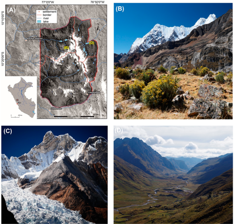
Figure 1.
Study area. (A) The location of the study area Cordillera Huayhuash in Peru; (B), (C) and (D) diverse environmental conditions in different parts of the study area (for location see (A)). Field images were taken in 2018 and 2019 by AE.
Figure 1.
Study area. (A) The location of the study area Cordillera Huayhuash in Peru; (B), (C) and (D) diverse environmental conditions in different parts of the study area (for location see (A)). Field images were taken in 2018 and 2019 by AE.

Figure 2.
Different lake types present in the Cordillera Huayhuash. (A) Moraine-dammed lakes Barrosacocha (upstream, W006) and Rasaqcocha (downstream, W005); (B) large bedrock-dammed Lake Huaracacocha (E012); (C) an example of relict (‘pampa’ type) lake near the Siula Punta; and (D) a small moraine- (in front) and two bedrock-dammed lakes (one of which is proglacial) near the Rasac Punta. All images were taken in 2018 and 2019 by AE.

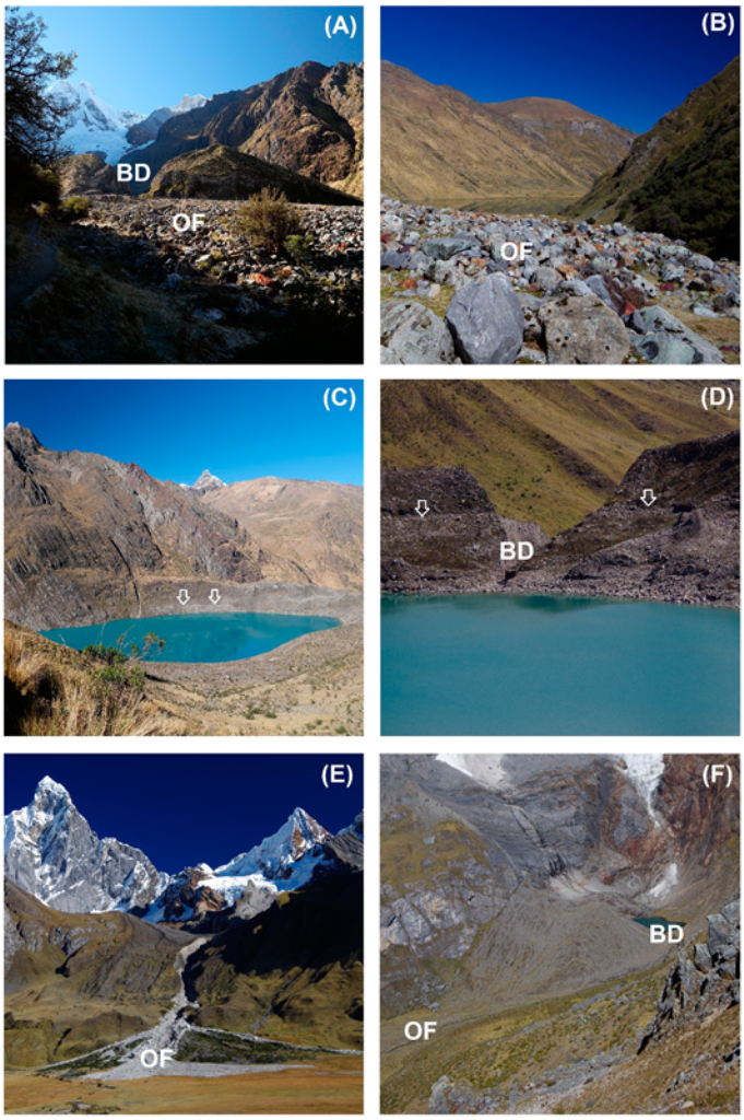
Figure 3.
Examples of diagnostic features of past glacial lake outburst floods (GLOFs) in the Cordillera Huayhuash. (A) Upstream view on breached moraine dam (BD) of Lake Solteracocha (in centre background) with outwash fan located directly downstream from the dam (OF); (B) downstream view over this outwash fan (OF), the largest boulders are > 2 m in diameter; (C) visible evidence of Solteracocha pre-GLOF lake water level (arrows; GLOF in 1932); (D) downstream view through breached moraine dam (BD) of Lake Gangrajanca and pre-GLOF lake water level (arrows); (E) fresh outwash fan (OF) of recent ambiguous event associated with lake Chaclan; (F) breached moraine dam (BD) and partly vegetation-covered outwash fan (OF) of Unnamed lake (W032). All images were taken in 2018 and 2019 by AE.

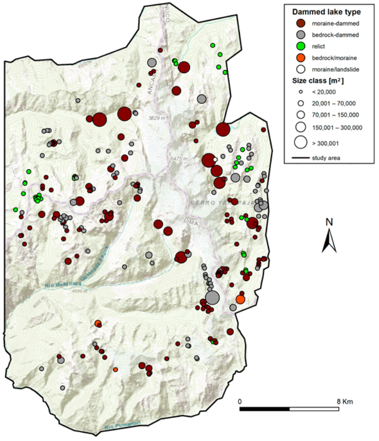
Figure 4.
Lake inventory of the Cordillera Huayhuash with lake dam types (see Section 2.1 and Figure 2) and lake sizes. Background map: [40].
Figure 4.
Lake inventory of the Cordillera Huayhuash with lake dam types (see Section 2.1 and Figure 2) and lake sizes. Background map: [40].

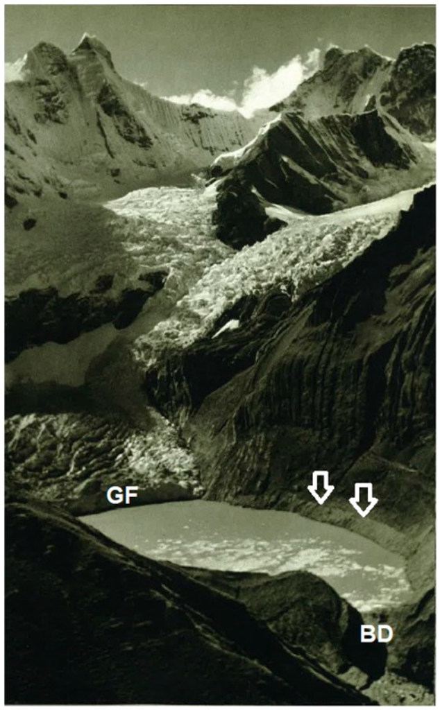
Figure 5.
Lake Solteracocha in the 1930s (most likely in 1936), shortly after dam failure in 1932. Breached moraine dam (BD) is visible in lower right corner; arrows indicate pre-GLOF lake water level (also visible on Figure 3C). Note that the lake was still proglacial at the time (GF–glacier front). Image modified from [9].

Figure 6.
Map of the GLOF susceptibility of 46 large lakes (>20,000 m2) of the Cordillera Huayhuash. Background map: [40].
Figure 6.
Map of the GLOF susceptibility of 46 large lakes (>20,000 m2) of the Cordillera Huayhuash. Background map: [40].


Table 1.
Five scenarios considered in GLOF susceptibility assessment and thresholds of GLOF susceptibility classes. Thresholds of individual susceptibility classes were derived from the analysis of previous GLOFs [34,39].
| GLOF Mechanism | |||
|---|---|---|---|
| Dam Overtopping | Dam Failure | ||
| Both Bedrock and Moraine-Dammed Lakes | Moraine-Dammed Lakes Only | ||
| Triggering event | Slope movement into the lake | Scenario 1 | Scenario 3 |
| Zero to negligible: <0.200 | Zero to negligible: <0.100 | ||
| Low: 0.200 to 0.499 | Low: 0.100 to 0.199 | ||
| Medium: 0.500 to 0.899 | Medium: 0.200 to 0.599 | ||
| High: >0.899 | High: >0.500 | ||
| Flood wave from an upstream lake | Scenario 2 | Scenario 4 | |
| Zero to negligible: * | Zero to negligible: * | ||
| Low: * | Low: * | ||
| Medium: * | Medium: * | ||
| High: * | High: * | ||
| Strong earthquake | Not applicable | Scenario 5 | |
| Zero to negligible: <0.050 | |||
| Low: 0.050 to 0.149 | |||
| Medium: 0.150 to 0.199 | |||
| High: >0.200 | |||
* Depending on the outburst scenario (and the resulting susceptibility assessment values) of lakes located upstream.
Table 2.
Lake inventory-distribution of lake types on the east and west of the range divide.
| Area [km2] | Lake Type | Sum | ||||||
|---|---|---|---|---|---|---|---|---|
| M | B | Relict | M + B | L + M | ||||
| Mountain range divide | West | 3.16 | 85 | 62 | 18 | 2 | 0 | 167 |
| East | 3.15 | 52 | 30 | 19 | 1 | 1 | 103 | |
| Sum | 6.31 | 137 | 92 | 37 | 3 | 1 | 270 | |
Lake type: B = bedrock-dammed, L = landslide-dammed, M = moraine-dammed.
Table 3.
Characteristics of the 270 lakes of the Cordillera Huayhuash.
| Characteristics | Mountain Side | Entire Range | Lake Type | ||||||
|---|---|---|---|---|---|---|---|---|---|
| West | East | M | B | Relict | M + B | L + M | |||
| Number of lakes | 167 | 103 | 270 | 137 | 92 | 37 | 3 | 1 | |
| Average lake area [m2] | 18,907 | 30,589 | 23,363 | 34,700 | 14,650 | 1543 | 71,550 | 5500 | |
| Area classes [1000 m2] | 100–700 | 7 | 8 | 15 | 11 | 4 | 0 | 0 | 0 |
| 50–99.9 | 5 | 6 | 11 | 6 | 4 | 0 | 1 | 0 | |
| 20–49.9 | 17 | 3 | 20 | 14 | 5 | 0 | 1 | 0 | |
| 10–19.9 | 10 | 10 | 20 | 12 | 6 | 2 | 0 | 0 | |
| 5–9.9 | 25 | 5 | 30 | 20 | 9 | 0 | 0 | 1 | |
| 2–4.9 | 29 | 12 | 41 | 16 | 23 | 2 | 0 | 0 | |
| 1–1.9 | 17 | 15 | 32 | 13 | 12 | 7 | 0 | 0 | |
| 0.5–0.9 | 23 | 24 | 47 | 23 | 13 | 10 | 1 | 0 | |
| 0.2–0.4 | 34 | 20 | 54 | 22 | 16 | 16 | 0 | 0 | |
| Elevation [m a.s.l.] | Minimum | 4061 | 4161 | 4061 | 4061 | 4198 | 4437 | 4812 | 4293 |
| Maximum | 5064 | 4963 | 5064 | 5040 | 5064 | 4973 | 4893 | 4300 | |
| Average | 4776 | 4609 | 4706 | 4684 | 4754 | 4669 | 4857 | 4297 | |
| Surface | yes | 74 | 33 | 107 | 58 | 33 | 13 | 3 | 0 |
| no | 93 | 70 | 163 | 79 | 59 | 24 | 0 | 1 | |
| Glaciated | no | 75 | 57 | 132 | 41 | 56 | 34 | 1 | 0 |
| Catchment | yes | 92 | 46 | 138 | 96 | 36 | 3 | 2 | 1 |
| Pro glacial | yes | 6 | 4 | 10 | 2 | 7 | 0 | 1 | 0 |
| no | 161 | 99 | 260 | 135 | 85 | 37 | 2 | 1 | |
Lake type: B = bedrock-dammed, L = landslide-dammed, M = moraine-dammed.
Table 4.
Overview of past GLOFs in the Cordillera Huayhuash.
| Lake Name (ID) | Location | Catchment | Dam Type | Water Release | Magnitude | Timing | Damage and Additional Info | References |
|---|---|---|---|---|---|---|---|---|
| Solteracocha (W002) | 10.2333° S, 76.9379° W 4126 m a.s.l. | P | M | DB | extreme | 14th March 1932 | Considerable damage reported | [7,9,14,33] |
| Sarapococha (W018) | 10.3122° S, 76.9134° W 4492 m a.s.l. | P | M | DB | major to extreme | 1940s or earlier | Minor damage reported | [9] |
| Sarapococha (W018) | 10.3122° S, 76.9134° W 4492 m a.s.l. | P | M | DB/DO (?) | major | February 1981 | Roads and bridge damaged in Cajatambo area | [7] |
| Juraucocha (W021) | 10.3358° S, 76.8967° W 4371 m a.s.l. | P | M | DB | major | 1940s or earlier | Minor damage reported | [9] |
| Rurigallay (W019) | 10.3171° S, 76.9063° W 4480 m a.s.l. | P | M | DB | extreme | 20th April 1941 | Several deaths, bridges and paths destroyed | [9,14] |
| Gangrajanca (E006) | 10.2665° S, 76.8767° W 4225 m a.s.l. | A | M | DB | minor | January 1999 | Flood likely absorbed by downstream Lake Carhuacocha (E005) | This study |
| Jancacuta (W032) | 10.2128° S, 76.9275° W 4349 m a.s.l. | P | M | DB | minor | Before 2011 | No damage reported, likely attenuated in pampa | This study |
| Unnamed (W023) | 10.3646° S, 76.8742° W 4763 m a.s.l. | P | B | DO | minor to major | Before 1984 | No damage reported, likely attenuated in pampa | This study |
| Unnamed (W030) | 10.2030° S, 76.9168° W 4558 m a.s.l. | P | M | DB | minor | Before 1984 | Flood absorbed by downstream Lake Garagcocha (W001) | This study |
| Unnamed (E087) | 10.3441° S, 76.8635° W 4808 m a.s.l. | A | M | DO (?) | minor | Before 2010 | No damage reported, likely attenuated in pampa | This study |
| Chaclan (E004) | 10.2413° S, 76.8885° W 4505 m a.s.l. | A | M | DO (?) | minor to major | 2014 to 2017 | Ambiguous, likely minor GLOF or debris flow | This study |
| Caramarca (W012) | 10.2934° S, 76.9287° W 4593 m a.s.l. | P | M | DO (?) | minor | Before 1985 | Ambiguous, likely minor GLOF | This study |
| Unnamed (W085) | 10.2968° S, 76.9415° W 4882 m a.s.l. | P | CD | DO | minor | Before 1976 | Ambiguous, likely minor GLOF or debris flow | This study |
| Unnamed (W097) | 10.3168° S, 76.97985° W 4952 m a.s.l. | P | M | DO (?) | minor | Before 2010 | Ambiguous, likely minor GLOF or debris flow | This study |
Catchment: P—Pativilca (Pacific Ocean); A—Amazon (Atlantic Ocean), dam type: M—moraine; B—bedrock dam; CD—combined dam, water release: DB—dam breach; DO—dam overtopping. Magnitude: extreme—clearly developed GLOF diagnostic features, large volumes involved, reported damage and far-reaching geomorphic imprints downstream; major—some of the diagnostic features developed, traceable geomorphic imprints downstream, possible damage; minor—some of the diagnostic features developed, minor geomorphic imprints directly downstream the lake, no damage.
© 2020 by the authors. Licensee MDPI, Basel, Switzerland. This article is an open access article distributed under the terms and conditions of the Creative Commons Attribution (CC BY) license (http://creativecommons.org/licenses/by/4.0/).
Share and Cite
MDPI and ACS Style
Baťka, J.; Vilímek, V.; Štefanová, E.; Cook, S.J.; Emmer, A. Glacial Lake Outburst Floods (GLOFs) in the Cordillera Huayhuash, Peru: Historic Events and Current Susceptibility. Water 2020, 12, 2664. https://doi.org/10.3390/w12102664
AMA Style
Baťka J, Vilímek V, Štefanová E, Cook SJ, Emmer A. Glacial Lake Outburst Floods (GLOFs) in the Cordillera Huayhuash, Peru: Historic Events and Current Susceptibility. Water. 2020; 12(10):2664. https://doi.org/10.3390/w12102664
Chicago/Turabian StyleBaťka, Jan, Vít Vilímek, Eva Štefanová, Simon J. Cook, and Adam Emmer. 2020. "Glacial Lake Outburst Floods (GLOFs) in the Cordillera Huayhuash, Peru: Historic Events and Current Susceptibility" Water 12, no. 10: 2664. https://doi.org/10.3390/w12102664
Note that from the first issue of 2016, this journal uses article numbers instead of page numbers. See further details here.