Hydrological Drought in Dongting Lake Area (China) after the Running of Three Gorges Dam and a Possible Solution
by
 , ,
, ,
Yizhuang Liu
1,2,3, 
Shu-Qing Yang
4,
Changbo Jiang
1,2,3,*,
Yuannan Long
1,2,3,
Bin Deng
1,2,3 and
Shixiong Yan
1 1
School of Hydraulic Engineering, Changsha University of Science & Technology, Changsha 410114, China
2
Key Laboratory of Dongting Lake Aquatic Eco-Environmental Control and Restoration of Hunan Province, Changsha 410114, China
3
Key Laboratory of Water-Sediment Sciences and Water Disaster Prevention of Hunan Province, Changsha 410114, China
4
School of Civil, Mining and Environmental Engineering, University of Wollongong, Wollongong 2522, Australia
*
Author to whom correspondence should be addressed.
Water 2020, 12(10), 2713; https://doi.org/10.3390/w12102713
Submission received: 24 August 2020
/
Revised: 21 September 2020
/
Accepted: 25 September 2020
/
Published: 28 September 2020
(This article belongs to the Special Issue Climate Change and Human Impact on Freshwater Water Resources: Rivers and Lakes)
Abstract
:Dongting Lake is located at the downstream of Three Gorges Dam (TGD) and the hydrological drought is intensified after the impoundment of TGD as the dry period has been extended from 123 days/year before the operation of TGD (1981–2002) to 141 days/year (2003–2016) on average. Particularly, the Dongting Lake’s water shortage becomes very severe. To solve the problem caused by upstream dams, an innovative flood control scheme (IFCS) was introduced, and its feasibility of application in Dongting Lake is studied using the hydrodynamic module of Mike 21. The results show the IFCS can effectively convert the peak discharge of floodwater in wet seasons into water resources in dry seasons as the IFCS could significantly increase the usable water storage of the lake. For example, the usable water storage could increase to 2.85 billion m3 and 1.81 billion m3 in the extreme drought year of 2006 and 2011, respectively. The average increment of the water level would be about 0.4 m, 0.6 m, and 0.5 m in the West Dongting Lake (WDL), South Dongting Lake (SDL), and the East Dongting Lake (EDL), respectively, if the water stored in the inner lake was discharged uniformly in 30 days (27 November to 27 December 2006) with the application of IFCS. This study may provide an innovative method to alleviate the water shortage problem in Dongting Lake and other similar lakes.
1. Introduction
Lakes play an important role in the water supply for agricultural, industrial, commercial, and residential use. However, the extreme hydrological drought event happens more frequently in the lake area due to climate change and human activities in recent years [1]. The hydrological drought has attracted increasing worldwide attention for the ever-increasing demand on freshwater sources due to population growth, urbanization and industrialization. Climate change often results in effects such as higher evaporation, lower precipitation, and higher temperature, which would exacerbate the drought severity [2,3]. Meanwhile, numerous studies have shown that human activities (e.g., dam construction, river dredging, and sand mining, etc.) would decrease the inflow to the lake directly or accelerate the water flow out of the lake [4,5,6,7,8]. For example, the impoundment of the upstream dam leads to an overall reduction of the downstream water level, especially during the dry season; thus, the hydrological drought in the downstream-linked lakes is intensified [5,9,10].
Dongting Lake, the second-largest freshwater lake in China, is located in the middle reach of Yangtze River. Its hydrological cycle has been changed significantly by the Three Gorges Dam [1,5,11,12,13] as its inflow to the lake has been reduced in dry periods, especially from September–December in the recent decades. Consequently, its water level and water surface areas have been reduced significantly, which is caused by the TGD after 2003 [12]. More specifically, the statistics show that, when compared with the pre-TGD period, the starting date of the dry season occurs earlier and the duration of the dry season lasts longer after TGD’s operation in 2003 [8,14,15,16]. For example, Dongting Lake has experienced extreme drought events in 2006 and 2011 with the water surface area of about 350 km2 (i.e., 1/8 of the surface area of Dongting Lake in the wet season) in the dry season [17]. Moreover, in 2011, extremely low water level period lasted 80 days in the Dongting Lake area and hundreds of thousands of residents suffered the water shortage problem [17].
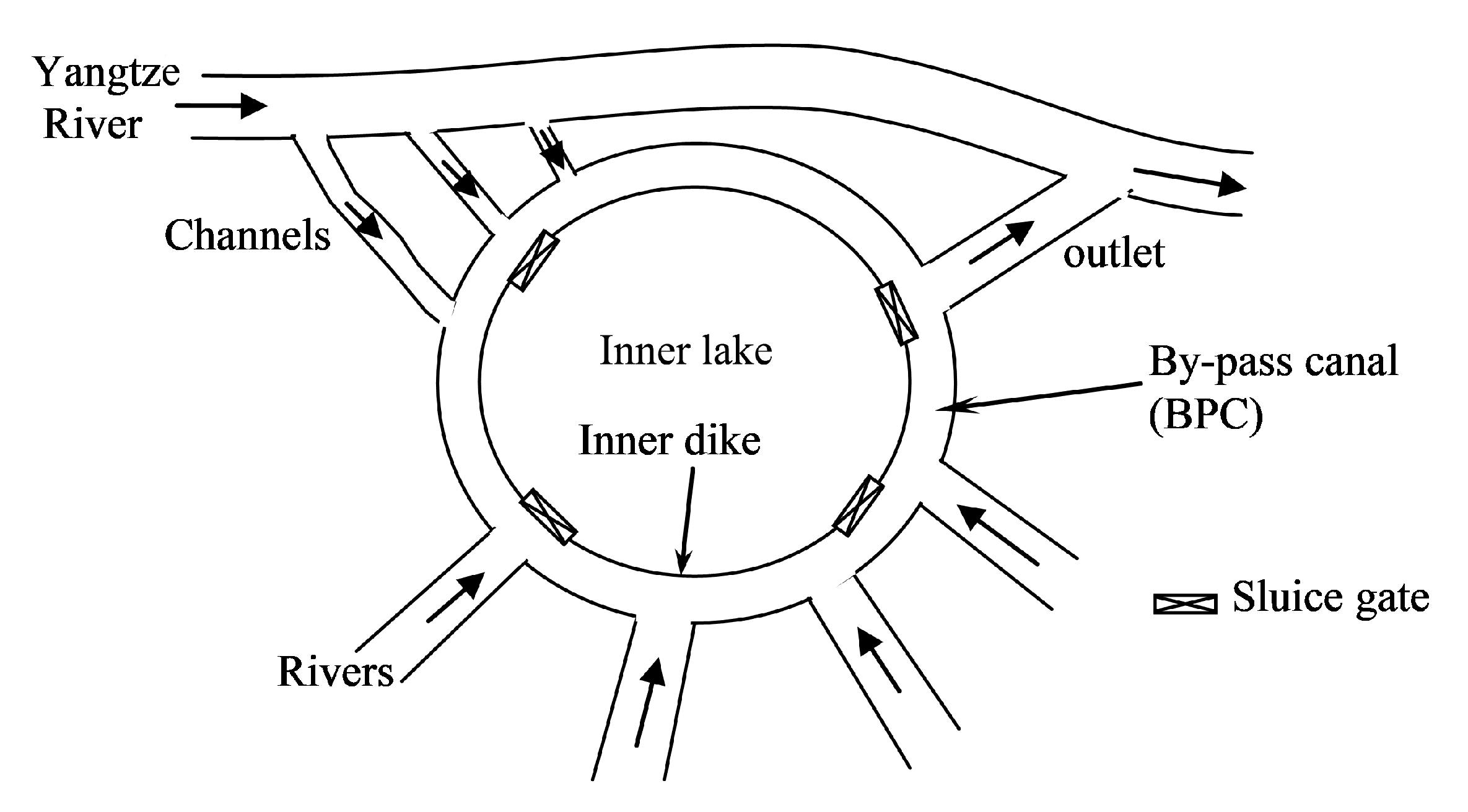
Previous studies mainly focus on the identification and characteristics of the hydrological drought as well as the factors that induce the extreme drought event in the Dongting Lake area [1,8,9,14,15,16]. Few studies investigate how to enhance the water supply of Dongting Lake [18,19]. Actually, apart from the environmental change (e.g., climate change and human activities), one of the main reasons for the water shortage problem in the Dongting Lake area is that the lake cannot contain its floodwater till the dry period since it is connected with Yangtze River directly, as shown in Figure 1. Therefore, to solve its water shortage problem, one has to convert its floodwater into water resources in the dry period. Yang et al. [20] and Liu et al. [21] proposed an innovative flood control scheme (IFCS) as shown in Figure 1. Together with the existing dike surrounding the lake, they suggest building an inner dike with several gates to form an inner lake for mitigation of flood disaster in wet seasons. At the beginning of wet seasons, the lake water is lowered to its dead water level. During the flood period, the peak floodwater could be diverted into the inner lake for storage by opening the gates, thus the inner lake functions as a giant flood-detention pond. More details could be found in the previous study [21]. The stored water will be released when the gates are open to regulate the outflow in the dry seasons. Therefore, a huge amount of floodwater stored in the inner lake can be converted to water resources in dry seasons.
In this paper, the effect of TGD on the hydrological drought was analyzed using 35 years (1981–2016) of hydrological data observed at Chenglingji station, which is the typical station to represent the water level in Dongting Lake [8]. The feasibility of applying the IFCS to increase the usable water storage of Dongting Lake was examined using the hydrodynamic module of Mike 21. The main objectives of this paper were to: (1) analyze the effect of the TGD on the hydrological drought in the Dongting Lake area; (2) examine the usable water storage of Dongting Lake after applying the IFCS; (3) study its feasibility for enhancing the water supply in the Dongting Lake area. This study may provide an innovative method to alleviate the water shortage problem in Dongting Lake and other similar lakes.
2. Materials and Methods
2.1. Study Area
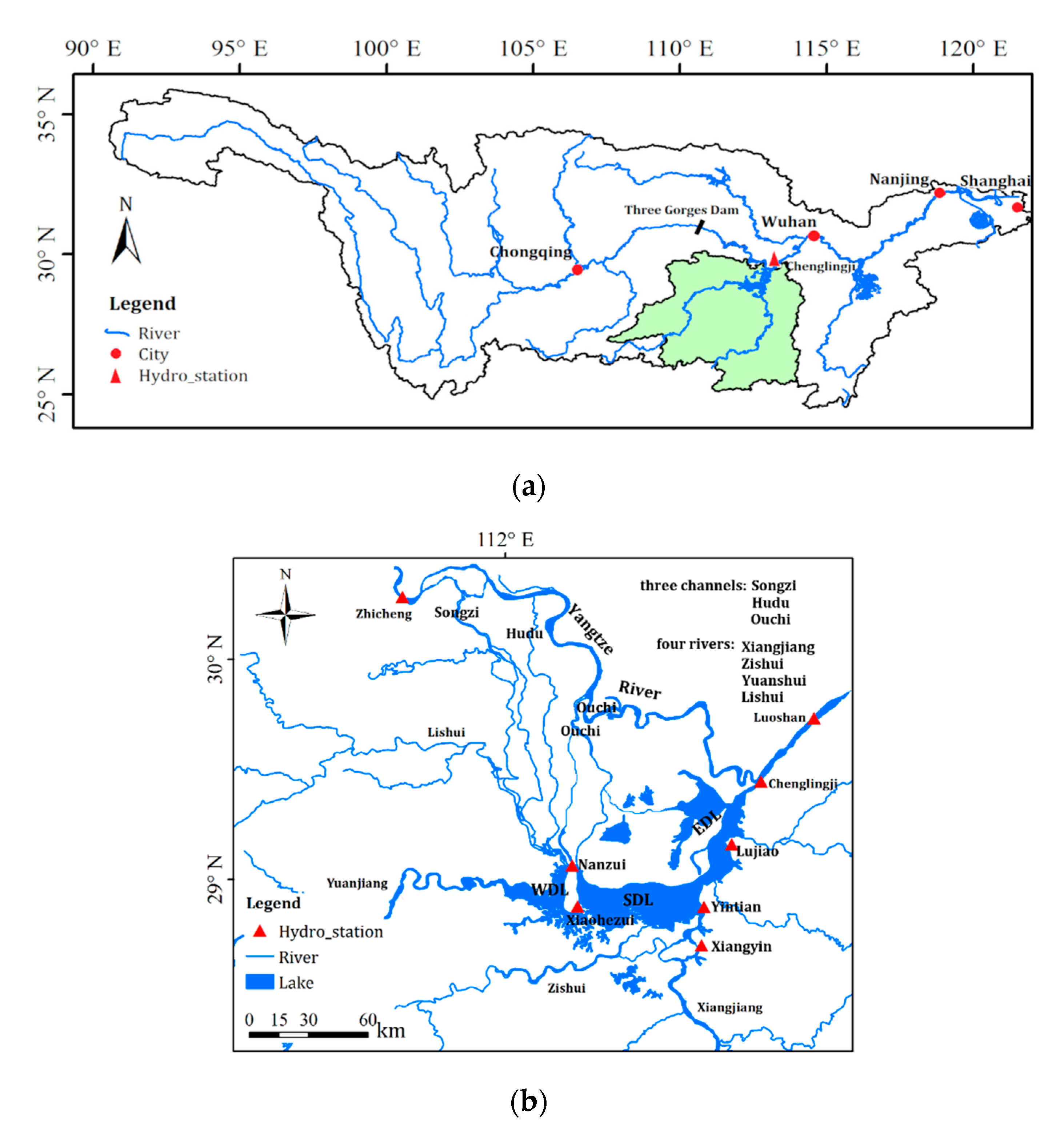
Dongting Lake (28°20′–30°20′ N, 111°30′–113°15′ E) is the second-largest freshwater lake in China, which provides water for millions of people who live in the surrounding area and downstream of the lake. The lake is located at approximately 400 km downstream away from Three Gorges Dam (TGD, see Figure 2) and thereby is considerably affected by TGD. Dongting Lake exhibits seasonal variability of the water surface area from about 2670 km2 in the wet season to approximately 710 km2 in the annual dry season. The variation of the annual water level is 12.7 ± 1.8 m based on the daily measured water level from 1961–2014 at Chenglingji station, which is considered as the typical hydro-station of Donging Lake [22]. The mean annual precipitation and evaporation in the Dongting Lake area are about 1363 mm/year and 729 mm/year, respectively [23].
The whole lake is divided into three sub-lakes (i.e., West Dongting Lake, WDL; South Dongting Lake, SDL; and East Dongting Lake, EDL, see Figure 2b). It receives inflow mainly from the “four rivers” (Xiangjiang, Zishui, Yuanshui, and Lishui) and Yangtze River through the “three channels” (Songzi, Hudu and Ouchi). Other inflows sources include local rainfall and small streams around lake shoreline. The lake discharges to the Yangtze River through Chenglingji station.
2.2. Method
2.2.1. M-K Method
The Mann-Kendall (M-K) test [24,25] is a non-parametric test to identify the long-term trend of the duration of the dry period in this study. It is widely used in the analysis of hydrological time series [26]. Given a time series of for each variable, the M-K statistic () is defined as:
where
The mean and variance of dk were:
The statistic value UF(dk) is calculated by:
The backward sequence (UB) is calculated using the same method that applied to the inverted series of xi. A positive UF(dk) indicates an increasing trend, while a negative value represents a declining trend. A change-point occurs at the intersection of UF and UB within the confidence interval.
2.2.2. Hydrodynamic Model
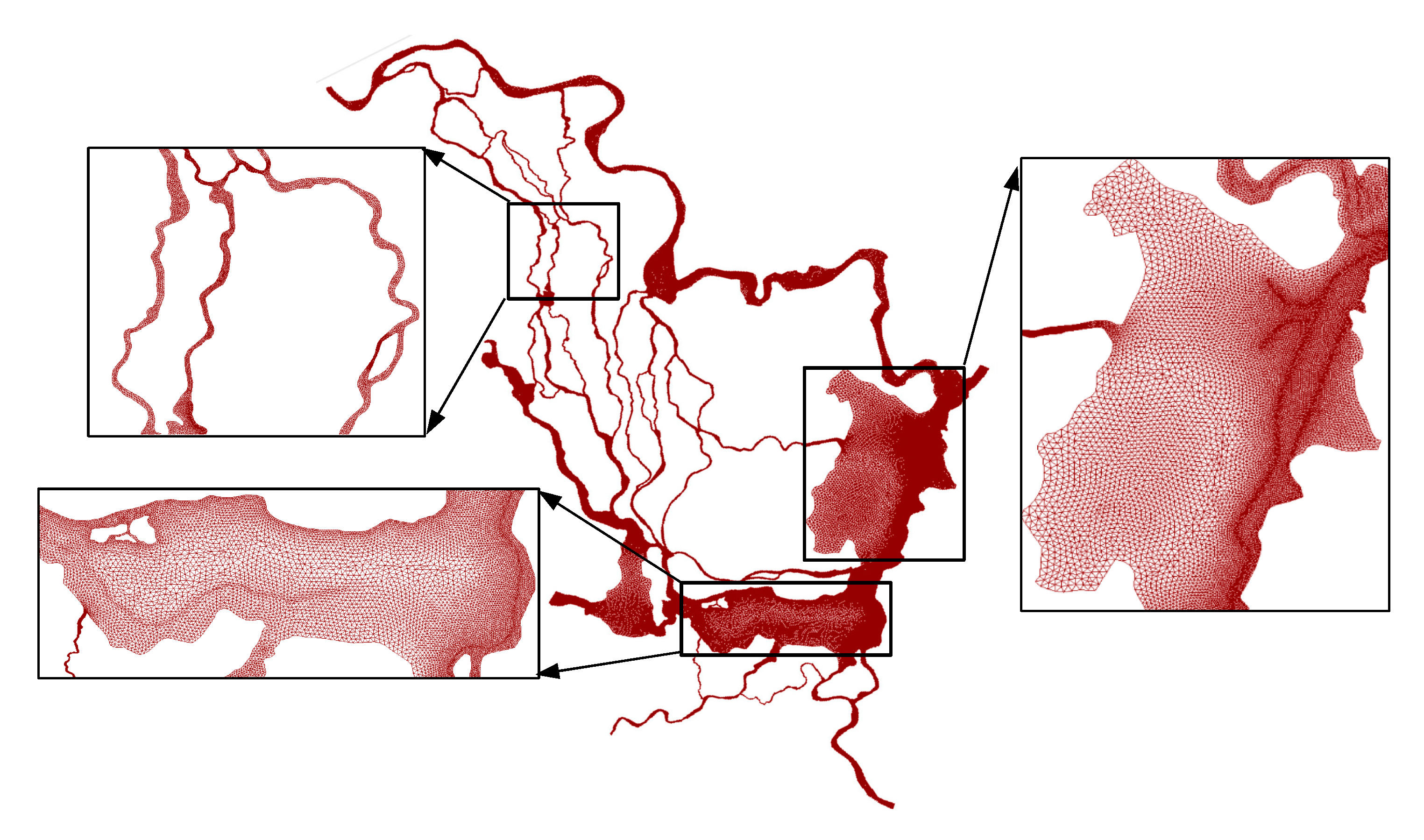
A previously calibrated 2D depth-averaged hydrodynamic model (Mike 21 FM) was used in this study since it could simulate the hydrodynamic process well in Dongting Lake [21]. The model covers the whole area of Dongting Lake, “three channels”, “four rivers” and a part of the middle reach of Yangtze River. It was constructed by 210,341 triangular elements to capture the complex lake bathymetry (see Figure 3). The element size varies from 30 m in narrow channels to 700 m in the lake area by trial and error. The upstream boundary conditions were specified as the daily inflow records of Yangtze River (i.e., Zhicheng station) and the four rivers (Xiangtan station, Taojiang station, Taoyuan station and Jinshi station). The downstream boundary condition used the rating curve observed at Luoshan station on Yangtze River [21]. The wetting and drying process function [27] was used as the water surface varies significantly in the lake area [28]. Previously calibrated parameters such as Manning roughness number (from 32 m1/3/s to 60 m1/3/s) of the lake and the minimum time step (i.e., 2s) were used in the current module. More details of the model could be found in the previous study [21], thus a brief description of the model is given here.
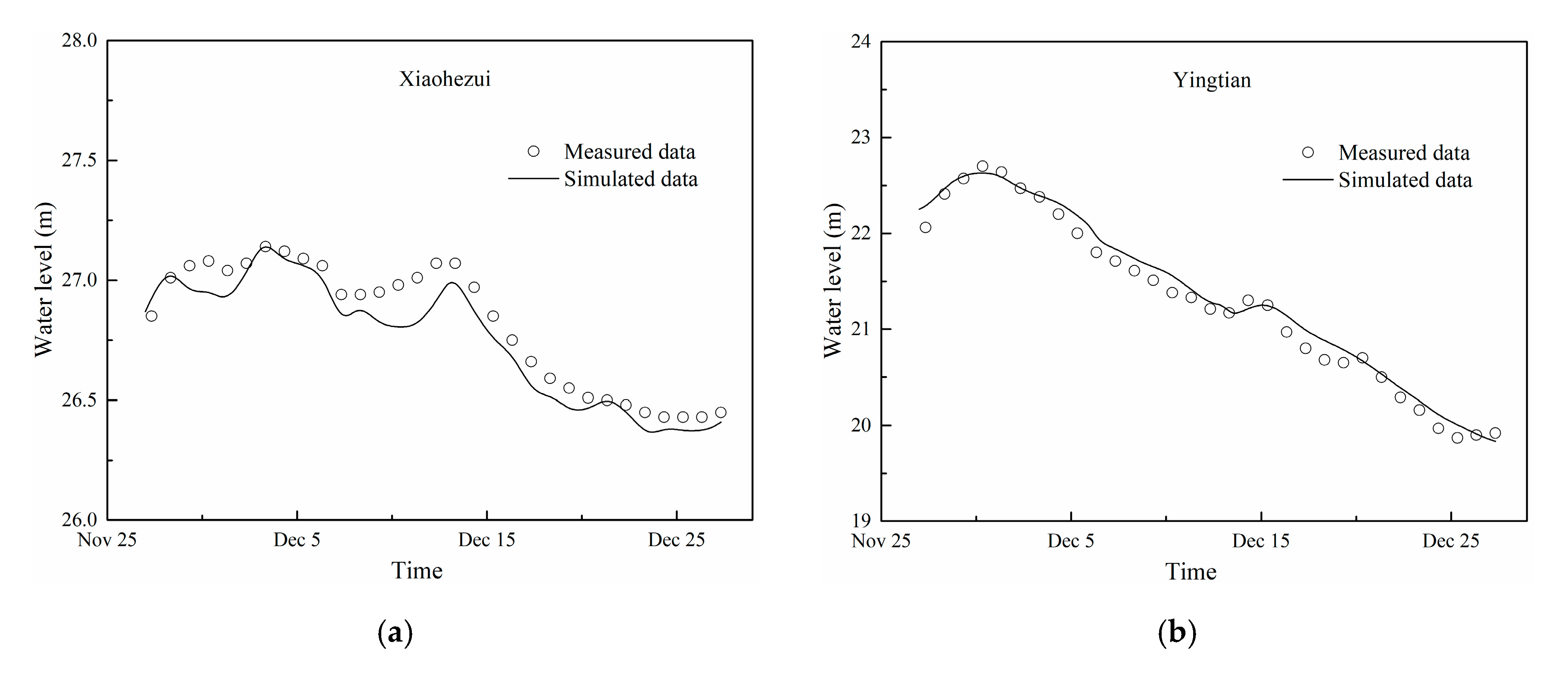
The 2D hydrodynamic model was validated using the measured water level at the stations in the lake (i.e., Nanzui, Yintan, Lujiao and Chenglji stations, see Figure 2) during the dry season of 2006. Figure 4 shows the comparison of the measured and simulated water level process at the selected stations in Dongting Lake. The results show that the model can simulate the water level fluctuation in the lake successfully since the simulated results agree well with the measured data. The uncertainty of the model was estimated by the Nash-Sutcliffe efficiency coefficients (NSE), determination coefficient (R2), the difference of the maximum water level, and the root-mean-square error (RMSE) (see Table 1). The result shows that the NSE value in ranges of 0.887 to 0.981, the R2 values are greater than 0.96, the RMSE values are less than 0.2 m and the average water level differences are within 0.15 m, which indicates that the hydrodynamic model could represent the flow process of the lake during the dry season.
2.3. The Preliminary Design of IFCS in Dongting Lake
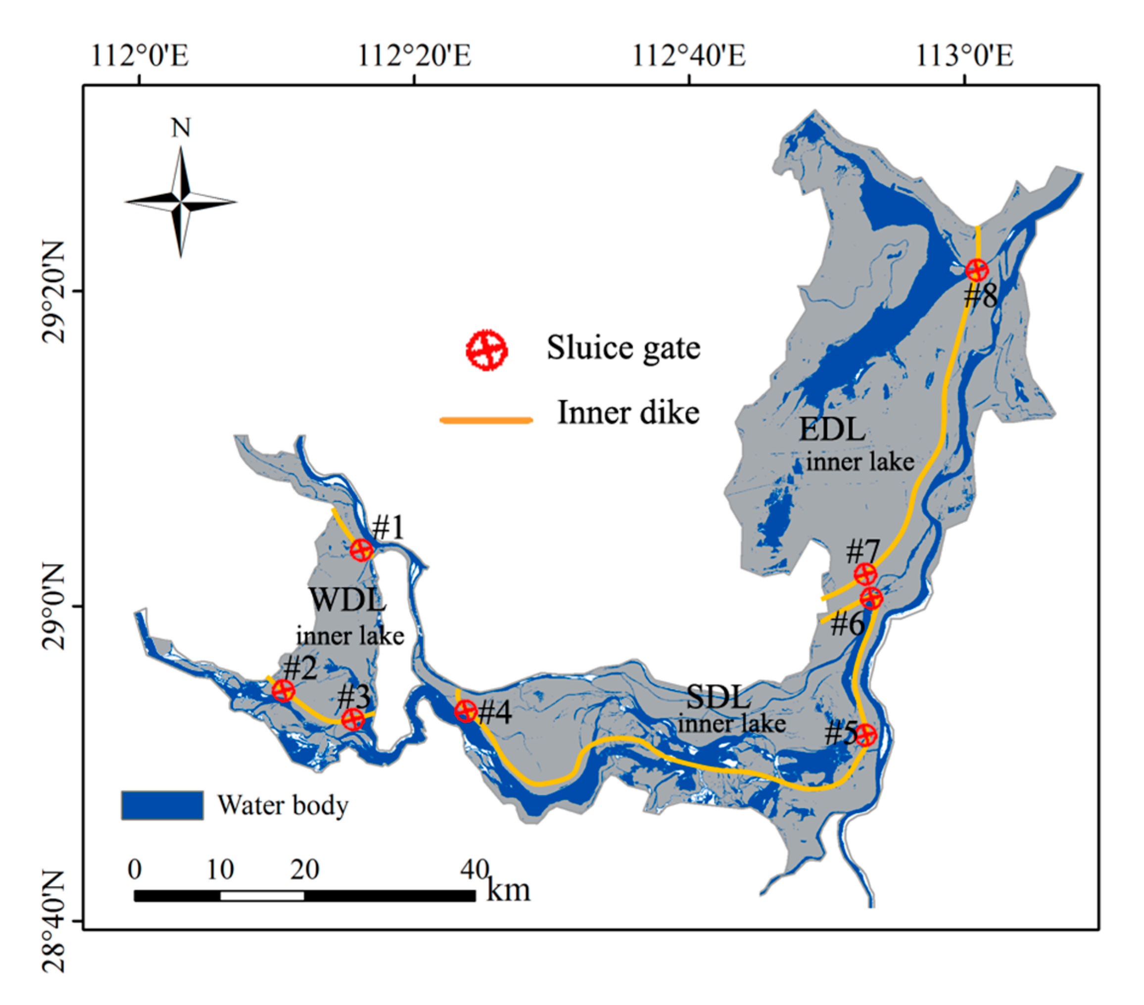
The inner dikes with sluice gates of the IFCS were proposed in Figure 5, where the gates are represented by the void red circle with a cross inside and the inner dikes are marked by the solid yellow line. The inner dikes are built along the mainstream in the Dongting Lake, thus the safe floodwater could be discharged to the downstream smoothly through the mainstream [21]. The area of the inner lake of WDL, SDL, and EDL is 190 km2, 560 km2, and 969 km2, respectively. The water level should be lowered to its dead water level (i.e., 29.0 m in WDL, 27.5 m in SDL, and 26 m in EDL) in the inner lake at the end of the dry season [21] and thereby there is enough flood control capacity to mitigate the flood disaster. During the flood season, the excess floodwater could be discharged into the inner lake by opening the sluice gate when the peak flood wave arrives [20] and the safe floodwater would flow to the downstream through the mainstream by closing the sluice gates. Therefore, a huge amount of floodwater is stored in the inner lake after the flooding period, which could be used to alleviate the water shortage crisis during the dry season. More details could be found in the previous study [21].
3. Results
3.1. Water Level in the Dry Season
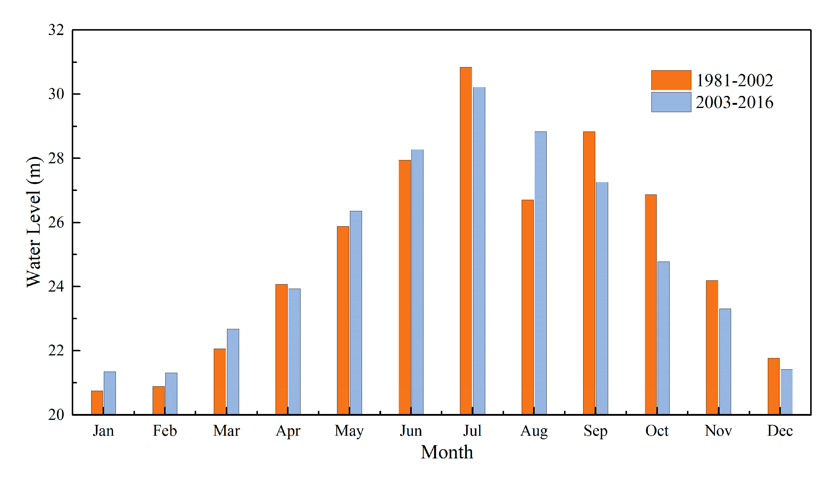
To analyze the long term change of the water level in the dry season of Dongting Lake, the period of 1981–2016 was divided into two typical periods, i.e., 1981–2002 (pre-TGD) and 2003–2016 (post-TGD), according to the operation year (i.e., 2003) of TGD [8,9]. Normally, the dry season starts from November to March (next year) in the Dongting Lake area. The water impoundment period is usually from the late September to December while the discharge period is from January to May, but it would be adjusted depending on the inflow from the upstream of TGD [29]. Figure 6 shows the monthly average water level during the two periods. The water level increases from January to March due to the discharge of TGD, while it decreased considerably from September to December due to the impoundment of TGD. Therefore, the drought severity could be alleviated from January to March (i.e., the average monthly water level increased by about 0.6 m), while it would be exacerbated from November (i.e., the mean monthly water level decreased by 0.88 m) and December (i.e., the average monthly water level decreased by 0.35 m) under the effect of TGD.
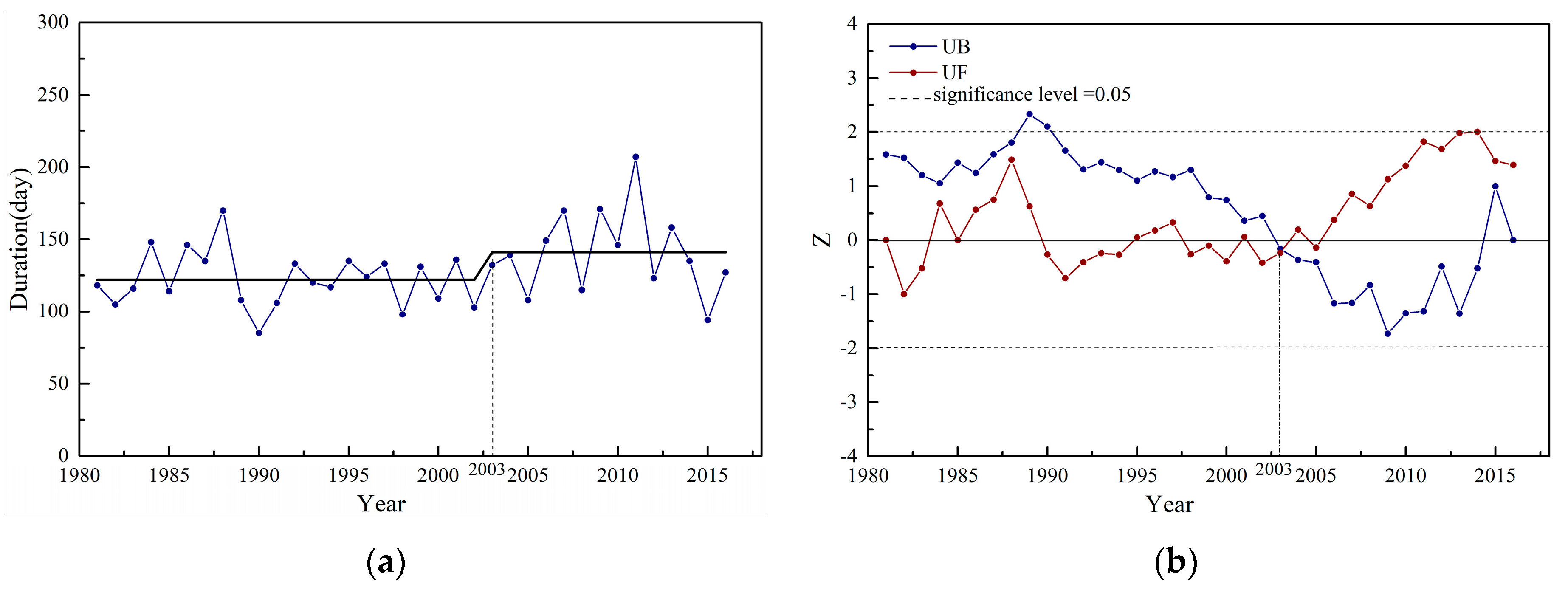
The dry spell of Dongting Lake can be defined as a period when the water level declines to 23 m at Chenglingji station. Figure 7a shows the duration of the dry period from 1981 to 2016. The result shows that the average duration is about 123 days/year during 1981–2002, while it increases to 141 days/year after the operation of TGD (2003–2016). The duration of the dry period increased by 18 days compared to the period of 1981–2002. Moreover, there is only one year that the duration is longer than 150 days during 1981–2002. However, 4 years that the duration is longer than 150 days occurred during 2003–2016. It indicates that a long duration of the dry period becomes more frequent after the operation of TGD. Meanwhile, the longest duration (i.e., 207 days) of the dry season in the past 4 decades occurred in 2011. Figure 7b shows the MK test of the duration of the dry season from 1981 to 2016. There is a sudden change in 2003, which is consistent with the operation of TGD. It could also be found that there is an increasing trend of the duration after the year 2003 as the UF value is positive.
3.2. Application of IFSC to Dongting Lake
As discussed in Section 3.1, the monthly average water level decreases significantly in November and December, and the duration of the dry period become longer after the operation of TGD. Therefore, the water shortage crisis becomes more and more serious in the Dongting Lake area. There is an urgent need to enhance the water level in November and December in the Dongting Lake area. The IFSC, as described in Section 2.3 and the previous study [21], could mitigate the flood by storing peak floodwater into the inner lake and this amount of floodwater could be used to alleviate the drought severity in the dry season. It might be a solution for the water shortage crisis in Dongting Lake area as it has a huge potential water storage capacity.
3.2.1. The Usable Water Storage of Dongting Lake
The usable water storage in each year can be estimated by the following equation:
where V is the usable water storage, S is the surface area of inner lake; hmax is the maximum water level of each element in Dongting Lake; he is the dead water level (i.e., 29.0 m in WDL, 27.5 m in SDL, and 26 m in EDL); hd is the designed water level of the embankment of each sub-lakes (i.e., 34.0 m in WDL, 33.1 m in SDL and 32.6 m in EDL). If the maximum water level is over the designed water level, we use the designed level to estimate the usable water storage.
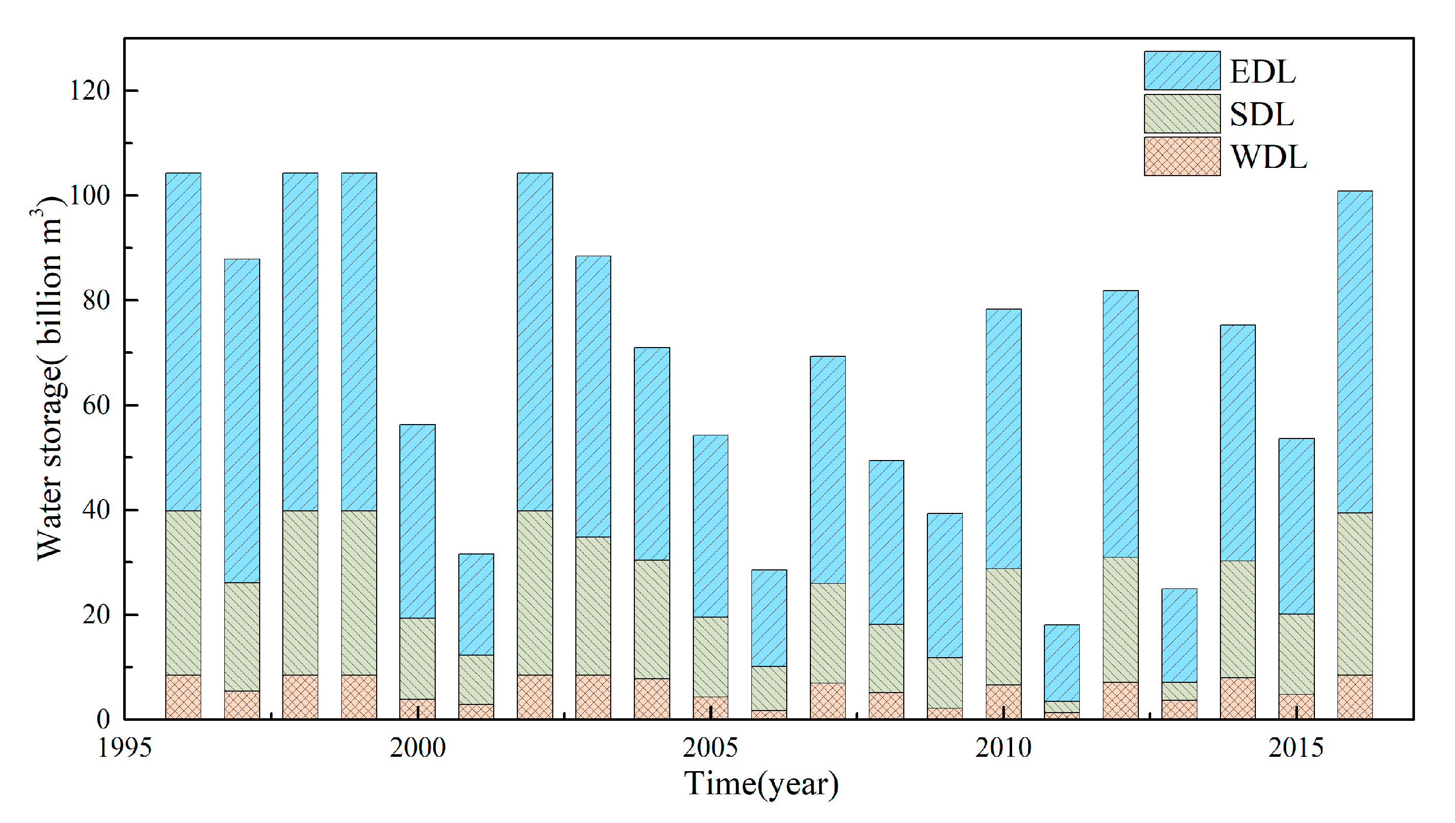
Figure 8 shows the usable water storage of Dongting Lake from 1996 to 2016. According to Equation (5), the usable water storage reaches up to 2.85 billion m3 and 1.81 billion m3 even in the extreme drought year of 2006 and 2011, respectively, while the total water storage content was less than 1 billion m3 during these two extreme drought years in the current condition [30].
3.2.2. The Effect of the IFSC on the Water Supply
From the abovementioned analysis, there is still a great potential water storage capacity in Dongting Lake even in the extreme drought years such as 2006 and 2011. In this section, the dry period (from 27 November to 27 December) of extreme drought year 2006 was taken as an example to estimate the effectiveness of the water supplement of the IFCS. Four gates (i.e., #1, #3, #5 and #8, see Figure 5) were used to regulate the water from the inner lake to the canal to increase the water supply. The usable water storage of WDL, SDL and EDL was calculated by Equation (5) (i.e., 0.17 billion m3 in WDL, 0.84 billion m3 in SDL and 1.84 billion m3 in EDL). We assumed the water stored in the inner lake would be discharged in 30 days (from 27 November to 27 December 2006) uniformly, and the flow rate at each gate was shown in Table 2.
The water level change response to the operation of the IFCS in Dongting Lake under one of the extreme drought years, i.e., 2006, was simulated based on the hydrodynamic model (Mike 21). Figure 9a shows the variation of water level in the BPC of West Dongting Lake (WDL, Nanzui station), South Dongting Lake (SDL, Yingtian station), and East Dongting Lake (EDL, Chenglingji station) after the application of IFCS. The results show that the water level increases significantly in Dongting Lake with the IFCS. Figure 9b presents the water level difference at all selected hydro-stations in Dongting Lake with the application of IFCS. The result shows that the IFCS imposes more influence on the water level in SDL than the other two sub-lakes (i.e., WDL and EDL). This is because the SDL receives water from the inner lake of WDL and SDL and thereby the increment of the water level in SDL is greater than that in SDL. For the EDL, the water level increases less than that in SDL because the EDL is affected by Yangtze River since the EDL connected the Yangtze River directly, although the discharge is the largest in EDL. The average increments of the water level were about 0.4 m, 0.6 m, and 0.5 m in WDL, SDL and EDL, respectively, while the largest increments of the water level were 0.5 m, 0.81 m, and 0.7 m, respectively. This indicates that the IFCS increases the water level significantly in Donging Lake, and thus it could alleviate the water shortage in the Dongting Lake area.
4. Discussions
Human activities such as dam construction, river channelization, land reclamation, etc. have significant impacts on the hydrological cycle [4,5,6,7,8,31]. Dam construction is considered to be one of the main factors that contribute to the low water level during the dry season in the Dongting Lake area [8]. For example, the discharge was reduced by 64% after the impoundment of TGD in 2006 compared with the annual average discharge in the pre-TGD period, which results in an obvious reduction of the water level at the downstream of TGD [19]. It also could be found that the water level decreases significantly after September (see Figure 6) due to the impoundment period of TGD, and the dry period starts earlier and lasts a long duration (i.e., the duration is 18 days longer than that in the pre-TGD period of 1981–2002).
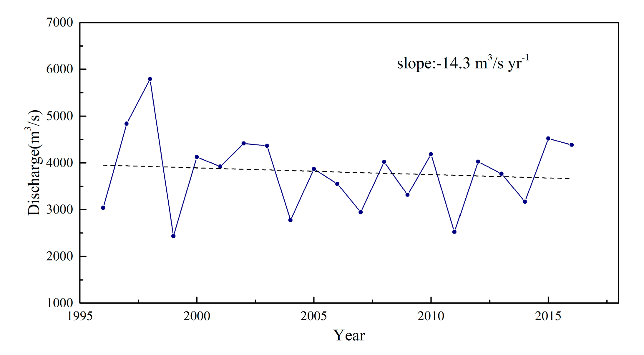
Figure 10 shows the long-term change of the inflow from Yangtze River to Dongting Lake via the “three channels” (see Figure 2). It can be found that the average discharge from the “three channels” decreased from 135 m3/s to 113 m3/s, although the average discharge from the upstream of Yangtze River has increased by 18% (from 5710 m3/s to 6747 m3/s) in the dry season after the operation of TGD. This can be ascribed to the lower water level at the middle reach of Yangtze River, on average about 1.6 m lower in the same dry period after the running of TGD [32]. Now, it is more difficult for the water flowing to the “three channels” from the Yangtze River by gravity. Similarly, the lower bed scoured by clean water from the TGD can increase the outgoing discharge from the lake to the Yangtze River. Consequently, less water can be stored in the lake in dry seasons. On the other hand, several large dams have been built on the “four rivers” during 1995–2016, which leads to the reduction of the inflow from “four rivers” with a decreasing rate of −14.3 m3 s−1/year (see Figure 11). Other reasons like the climate change would also affect the low water level during the dry season as the net rainfall decreased slightly in the post-TGD period [7,8,16] and thereby might intensify the water shortage problem. But other studies show that the effect of future climate on discharge in the Yangtze River Basin is still uncertain [33,34].
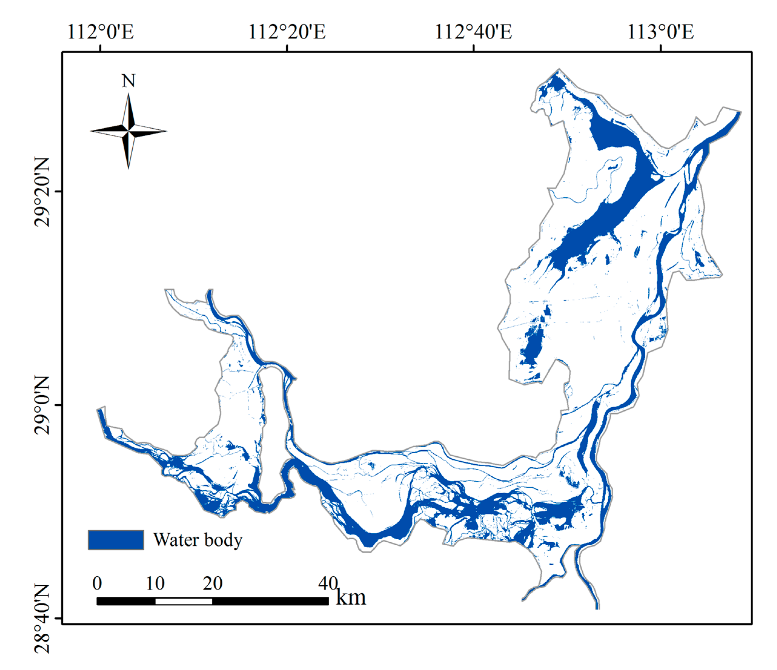
Apart from the decreasing amount of inflow to Dongting Lake, the water storage capability of the lake also plays an important role in water supply during the dry season. Figure 12 shows the water surface area of Dongting Lake during the dry season in 2006, which looks like several rivers, and the amount of the water storage content was only 0.6 billion m3 [30], about 1/10 of the annual water storage in Dongting Lake. Liu et al. [18] studied a scheme called “central lake reservoir” into the WDL, which could enhance the water supply during the dry season. However, it has limited effect on the water level except in WDL (e.g., the water level only increase about 0.15 m in EDL with “central lake reservoir”) due to the limited water storage of the reservoir. But the IFSC has huge potential water storage (see Figure 8) in Dongting Lake, with which the water level would increase at least 0.4 m even in the extreme drought year (i.e., 2006). Although the IFSC could efficiently mitigate the flood disaster [21] and alleviate the water shortage crisis, the operation of the IFSC and its effect on the environment needs further study.
5. Conclusions
Dam construction could alter streamflow significantly and thereby affects the hydrological drought in its downstream area. Dongting Lake, which is located at 400 km downstream of Three Gorges Dam (TGD), has been suffering a longer dry season due to the impoundment of TGD. Apart from the decreased inflow, another reason for the water shortage problem in the Dongting Lake area is that it lacks the water storage capability since it is connected with the Yangtze River directly. In this study, a flood control scheme called IFCS, which could store a huge amount of water, was applied into Dongting Lake to enhance the water supply during the dry season. The following conclusions can be drawn from the current study:
(1) The TGD causes a water shortage crisis in the water-rich Dongting area and the drought severity would be exacerbated, e.g., the average monthly water level decreased by 0.88 m and 0.35 m in November and December, respectively. The duration of the dry period (2003–2016) is 18 days longer than that in the period before the construction of TGD (1981–2002).
(2) The water crisis is solvable as Dongting Lake has a huge potential for water storage capability with the application of IFCS. The usable water storage reaches up to 2.85 billion m3 and 1.81 billion m3 even in the extreme drought year of 2006 and 2011, respectively.
(3) The average increment of the water level was about 0.4 m, 0.6 m, and 0.5 m in WDL, SDL, and EDL, respectively, if the water stored in the inner lake was discharged uniformly in 30 days. It indicates that the water level could be increased significantly by the application of IFCS, and thus it could alleviate the water shortage problem in the Dongting Lake area.
Author Contributions
Conceptualization, S.-Q.Y.; Formal analysis, Y.L. (Yizhuang Liu) and S.Y.; Supervision, C.J.; Validation, Y.L. (Yuannan Long), B.D.; Writing—original draft, Y.L. (Yizhuang Liu); Writing—review & editing, S.-Q.Y., C.J. All authors have read and agreed to the published version of the manuscript.
Funding
This research was funded by the Research Foundation of Education Bureau of Hunan Province, China (Grant No. 19C0059 and No. 19B036) and the National Natural Science Foundation of China (Grant No. 52079010).
Conflicts of Interest
The authors declare no conflict of interest.
References
- Zhang, D.; Zhang, Q.; Qiu, J.; Bai, P.; Liang, K.; Li, X. Intensification of hydrological drought due to human activity in the middle reaches of the Yangtze River, China. Sci. Total Environ. 2018, 637–638, 1432–1442. [Google Scholar] [CrossRef] [PubMed]
- Holm, T.M.; Koinig, K.A.; Andersen, T.; Donali, E.; Hormes, A.; Klaveness, D.; Psenner, R. Rapid physicochemical changes in the high Arctic Lake Kongressvatn caused by recent climate change. Aquat. Sci. 2012, 74, 385–395. [Google Scholar] [CrossRef]
- Shukla, S.; Safeeq, M.; Aghakouchak, A.; Guan, K.; Funk, C. Temperature impacts on the water year 2014 drought in California. Geophys. Res. Lett. 2015, 42, 4384–4393. [Google Scholar] [CrossRef] [Green Version]
- Altinbilek, D. The role of dams in development. Int. J. Water. Resour. D 2002, 18, 9–24. [Google Scholar] [CrossRef]
- Sun, Z.D.; Huang, Q.; Christian, O.; Thomas, H.; Ulf, M. Impacts and implications of major changes caused by the Three Gorges Dam in the middle reaches of the Yangtze River, China. Water Resour. Manag. 2012, 26, 3367–3378. [Google Scholar] [CrossRef]
- Lai, X.; Shankman, D.; Huber, C.; Yesou, H.; Huang, Q.; Jiang, J. Sand mining and increasing Poyang Lake’s discharge ability: A reassessment of causes for lake decline in China. J. Hydrol. 2014, 519, 1698–1706. [Google Scholar] [CrossRef]
- Lai, X.; Jiang, J.; Yang, G.; Lu, X.X. Should the Three Gorges Dam be blamed for the extremely low water levels in the middle–lower Yangtze River? Hydrol. Process 2013, 28, 150–160. [Google Scholar] [CrossRef]
- Yuan, Y.; Zeng, G.; Liang, J.; Huang, L.; Hua, S.; Li, F.; Zhu, Y.; Wu, H.; Liu, J.; He, X.; et al. Variation of water level in Dongting Lake over a 50-year period: Implications for the impacts of anthropogenic and climatic factors. J. Hydrol. 2015, 525, 450–456. [Google Scholar] [CrossRef]
- Han, Q.; Zhang, S.; Huang, G.; Zhang, R. Analysis of Long-Term Water Level Variation in Dongting Lake, China. Water 2016, 8, 306. [Google Scholar] [CrossRef] [Green Version]
- Li, X.; Liu, P.; Cui, Z.; Ming, B.; Yang, Z.; Xie, K.; Zhang, X. Reducing lake water-level decline by optimizing reservoir operating rule curves: A case study of the Three Gorges Reservoir and the Dongting Lake. J. Clean. Prod. 2020, 246, 121676. [Google Scholar] [CrossRef]
- Liu, Y.; Wu, G.; Zhao, X. Recent declines in China’s largest freshwater lake: Trend or regime shift? Environ. Res. Lett. 2013, 8, 14010–14019. [Google Scholar] [CrossRef]
- Zhou, Y.; Ma, J.; Zhang, Y.; Li, J.; Feng, L.; Zhang, Y.; Shi, K.; Brookes, J.D.; Jeppesen, E. Influence of the three Gorges Reservoir on the shrinkage of China’s two largest freshwater lakes. Glob. Planet. Chang. 2019, 177, 45–55. [Google Scholar] [CrossRef]
- Li, F.; Wang, Z.; Chao, N.; Song, Q. Assessing the Influence of the Three Gorges Dam on Hydrological Drought Using GRACE Data. Water 2018, 10, 669. [Google Scholar] [CrossRef] [Green Version]
- Liang, J.; Cai, Q.; Guo, S.; Xie, G.; Li, X.; Huang, L.; Zeng, G.; Long, Y.; Wu, H. MODIS-based analysis of wetland area responses to hydrological processes in the Dongting Lake. Acta Ecol. Sin. 2012, 32, 6628–6635. (In Chinese) [Google Scholar] [CrossRef] [Green Version]
- Feng, L.; Hu, C.; Chen, X.; Zhao, X. Dramatic inundation changes of China’s two largest freshwater lakes linked to the Three Gorges Dam. Environ. Sci. Technol. 2013, 47, 9628–9634. [Google Scholar] [CrossRef] [PubMed]
- Wu, H.; Zeng, G.; Liang, J.; Guo, S.; Dai, J.; Lu, L.; Wei, Z.; Xu, P.; Li, F.; Yuan, Y.; et al. Effect of early dry season induced by the Three Gorges Dam on the soil microbial biomass and bacterial community structure in the Dongting Lake wetland. Ecol. Indic. 2015, 53, 129–136. [Google Scholar] [CrossRef]
- Ji, H.; Wu, G.; Liu, Y. Sharp change of lake levels during the two extreme droughts and its hydroclimatic processes in Lake Dongting, China. J. Lake Sci. 2016, 28, 207–216. (In Chinese) [Google Scholar]
- Liu, H.; Deng, B.; Liu, Y.; Jiang, C.; Wu, Z.; Long, Y. Preliminary Numerical Analysis of the Efficiency of a Central Lake Reservoir in Enhancing the Flood and Drought Resistance of Dongting Lake. Water 2018, 10, 225. [Google Scholar] [CrossRef] [Green Version]
- Liu, H.; Jiang, C.; Yang, S.; Liu, Y.; Chen, J.; Long, Y.; Deng, B. A new lake treatment strategy for Dongting Lake based on central lake reservoir concept. Adv. Sci. Technol. Water Resour. 2018, 38, 19–25+31. (In Chinese) [Google Scholar]
- Yang, S.Q.; Liu, P.W. Strategy of water pollution prevention in Taihu Lake and its effects analysis. J. Great Lakes Res. 2010, 36, 150–158. [Google Scholar] [CrossRef] [Green Version]
- Liu, Y.; Yang, S.-Q.; Jiang, C.; Sivakumar, M.; Enever, K.; Long, Y.; Deng, B.; Khalil, U.; Yin, L. Flood Mitigation Using an Innovative Flood Control Scheme in a Large Lake: Dongting Lake, China. Appl. Sci. 2019, 9, 2465. [Google Scholar] [CrossRef] [Green Version]
- Lu, C.; Jia, Y.; Jing, L.; Zeng, Q.; Lei, J.; Zhang, S.; Lei, G.; Wen, L. Shifts in river-floodplain relationship reveal the impacts of river regulation: A case study of Dongting Lake in China. J. Hydrol. 2018, 559, 932–941. [Google Scholar] [CrossRef]
- Peng, J.; Li, G.; Wu, F. Analysis on the Changes of Utilizable Precipitation over Dongting Lake Region during the Past 100 Years. Ecol. Environ. Sci. 2017, 26, 104–110. [Google Scholar]
- Mann, H.B. Nonparametric tests against trend. Econometrica 1945, 13, 245–259. [Google Scholar] [CrossRef]
- Kendall, M.G. Rank Correlation Methods; Griffin: London, UK, 1975. [Google Scholar]
- Hamed, K.H. Trend detection in hydrologic data: The Mann–Kendall trend test under the scaling hypothesis. J. Hydrol. 2008, 349, 350–363. [Google Scholar] [CrossRef]
- Danish Hydraulic Institute (DHI). MIKE 21 Flow Model: Hydrodynamic Module User Guide; DHI Water and Environment: Hørsholm, Denmark, 2014. [Google Scholar]
- Yamashiki, Y.; Nakamura, T.; Kurosawa, M.; Matsui, S. Ecosystem approach to mitigate impacts of sedimentation on the hydrological cycle and aquatic ecosystem. Hydrol. Process. 2006, 20, 1273–1291. [Google Scholar] [CrossRef]
- Changjiang Water Resource Commission (CWRC). Regulation for Cascade Operation of Three Gorges Dam- Gezhouba Water Control Project; CWRC Report: Wuhan, China, 2019. (In Chinese) [Google Scholar]
- Xu, W.; Kang, W.; He, J. Temporal and spatial variation of storage capacity in Dongting Lake. J. Soil Water Conserv. 2015, 29, 62–67. (In Chinese) [Google Scholar]
- Xu, K.; Milliman, J.D. Seasonal variation of sediment discharge from the Yangtze River before and after impoundment of the Three Gorges Dam. Geomorphology 2009, 104, 278–283. [Google Scholar] [CrossRef]
- China Institute of Water Resource and Hydropower Research (IWHR). Study on the Relationship between the Yangtze River and the Dongting Lake under the New Water and Sediment Conditions; IWHR Report: Beijing, China, 2013. (In Chinese) [Google Scholar]
- Birkinshaw, S.J.; Guerreiro, S.B.; Nicholson, A.; Liang, Q.; Quinn, P.; Zhang, L.; He, B.; Yin, J.; Fowler, H.J. Climate change impacts on Yangtze River discharge at the Three Gorges Dam. Hydrol. Earth Syst. Sci. 2016, 21, 1911–1927. [Google Scholar] [CrossRef] [Green Version]
- Gu, H.H.; Yu, Z.B.; Wang, G.L.; Wang, J.G.; Ju, Q.; Yang, C.G.; Fan, C.H. Impact of climate change on hydrological extremes in the Yangtze River Basin, China. Stoch. Environ. Res. Risk Assess. 2015, 29, 693–707. [Google Scholar] [CrossRef]
Figure 1.
The schematic of the IFCS in Dongting Lake.

Figure 2.
The location of Dongting Lake. The lake collects water from the Yangtze River through ‘three channels’ (Songzi, Hudu, and Ouchi) and ‘four rivers’ (Xiangjiang, Zishui, Yuanshui, and Lishui) and discharges to the Yangtze River at Chenglingji. (a) The location of Dongting Lake catchment; (b) Dongting lake and its main tributaries.

Figure 3.
The unstructured grid for the Mike 21 model.

Figure 4.
Comparison of water level process during the dry season (November to December) in 2006. (a) Xiaohezui; (b) Yingtian; (c) Lujiao; (d) Chenglingji.
Figure 4.
Comparison of water level process during the dry season (November to December) in 2006. (a) Xiaohezui; (b) Yingtian; (c) Lujiao; (d) Chenglingji.


Figure 5.
The layout of the IFCS in Dongting Lake.

Figure 6.
The average monthly water level in the two typical periods.

Figure 7.
The long-term change of the duration of the dry period. (a) The duration of the dry period from 1981 to 2016; (b) the M-K test of the duration.
Figure 7.
The long-term change of the duration of the dry period. (a) The duration of the dry period from 1981 to 2016; (b) the M-K test of the duration.

Figure 8.
The usable water storage capacity in Dongting Lake in each year (1996–2016).

Figure 9.
The variation of the water level with IFCS (27 November to 27 December 2016): (a) the fluctuation of the water level at the selected station; (b) the average and maximum water level differences in the Dongting Lake.
Figure 9.
The variation of the water level with IFCS (27 November to 27 December 2016): (a) the fluctuation of the water level at the selected station; (b) the average and maximum water level differences in the Dongting Lake.

Figure 10.
The long term change of the inflow from (a) “three channels” (b) Yangtze River (Zhicheng station).
Figure 10.
The long term change of the inflow from (a) “three channels” (b) Yangtze River (Zhicheng station).

Figure 11.
The long term change of the inflow from “four rivers”.

Figure 12.
The water surface area of Dongting Lake in the dry season (2006).


Table 1.
The Nash–Sutcliffe efficiency coefficients (NSE), R2 and the root mean square error (RMSE) calculated at the main hydrological stations in Dongting Lake.
Table 1.
The Nash–Sutcliffe efficiency coefficients (NSE), R2 and the root mean square error (RMSE) calculated at the main hydrological stations in Dongting Lake.
| Stations | NSE | R2 | RMSE | Average Difference (m) |
|---|---|---|---|---|
| Xiaohezui | 0.887 | 0.962 | 0.086 | 0.07 |
| Yingtian | 0.979 | 0.990 | 0.124 | 0.10 |
| Lujiao | 0.932 | 0.992 | 0.195 | 0.12 |
| Chenglingji | 0.981 | 0.994 | 0.10 | 0.08 |
Table 2.
The flow rate at each gate.
| Location | Gate | V (Billion m3) | Discharge (m3/s) |
|---|---|---|---|
| WDL | #1 | 0.17 | 32 |
| #3 | 32 | ||
| SDL | #5 | 0.84 | 324 |
| EDL | #8 | 1.84 | 710 |
© 2020 by the authors. Licensee MDPI, Basel, Switzerland. This article is an open access article distributed under the terms and conditions of the Creative Commons Attribution (CC BY) license (http://creativecommons.org/licenses/by/4.0/).
Share and Cite
MDPI and ACS Style
Liu, Y.; Yang, S.-Q.; Jiang, C.; Long, Y.; Deng, B.; Yan, S. Hydrological Drought in Dongting Lake Area (China) after the Running of Three Gorges Dam and a Possible Solution. Water 2020, 12, 2713. https://doi.org/10.3390/w12102713
AMA Style
Liu Y, Yang S-Q, Jiang C, Long Y, Deng B, Yan S. Hydrological Drought in Dongting Lake Area (China) after the Running of Three Gorges Dam and a Possible Solution. Water. 2020; 12(10):2713. https://doi.org/10.3390/w12102713
Chicago/Turabian StyleLiu, Yizhuang, Shu-Qing Yang, Changbo Jiang, Yuannan Long, Bin Deng, and Shixiong Yan. 2020. "Hydrological Drought in Dongting Lake Area (China) after the Running of Three Gorges Dam and a Possible Solution" Water 12, no. 10: 2713. https://doi.org/10.3390/w12102713
Note that from the first issue of 2016, this journal uses article numbers instead of page numbers. See further details here.