Evolution of Flood Regulation Capacity for a Large Shallow Retention Lake: Characterization, Mechanism, and Impacts


1
State Key Laboratory of Lake Science and Environment, Nanjing Institute of Geography and Limnology, Chinese Academy of Sciences, Nanjing 210008, China
2
University of the Chinese Academy of Sciences, 19(A) Yuquan Road, Beijing 100049, China
*
Author to whom correspondence should be addressed.
Water 2020, 12(10), 2853; https://doi.org/10.3390/w12102853
Submission received: 29 June 2020
/
Revised: 8 August 2020
/
Accepted: 12 October 2020
/
Published: 13 October 2020
(This article belongs to the Section Hydrology)
Abstract
:The retention lake often plays an important role in flood mitigation through the water storage and the lake–river interactions. However, the evolution of real-time flood regulation capacity remains poorly characterized. Using wavelet decomposition and flood peak removing ratios, this study presents a comprehensive evaluation of the characterization, mechanism, and impacts of the flood regulation capacity in Dongting Lake. The results indicate that the change of flood regulation effect of the lake can be well reflected by the multi-year changes in the variances of the inflow and outflow runoffs. The wavelet decomposition indicates that the flood regulation of the lake is mainly functioned on the high-frequency floods with durations less than 32 days. The average yearly flood peak removing ratios range from 0.13 to 0.56, but no significant tendency changes on the effect of the flood regulation capacity has happened during the study period. The changes in maximum regulation volume reveal that the flood regulation of the Dongting Lake is mainly a passive process decided by the complex river–lake relationship and the interactions among different processes of discharge and sediment. The impacts from the large volume reduction caused by sedimentation in the lake is compensated by the increased flood controlling water level, which in turn have resulted in the new phenomenon of “normal discharge, high water level and disaster” in the lake regions after the 1990s. The significant impacts on the lake–river relationship caused by the sediment reallocation from the operation of the Three Gorges Reservoir (TGR) have further changed the hydrological regimes between the lake and the Yangtze River. Influenced by the new lake-river interaction pattern the discharge passing capacity downstream the outlet of the lake is becoming a key factor that affects the flood regulation capacity, which is leading to a shift of the flood pressures from the lake region to the downstream of Yangtze in the near future.
1. Introduction
Lake–river systems are among the most diverse and dynamic ecosystems benefitting from the natural fluctuations of water level rhythms [1,2]. Hydrological connectivity and flood pulses, as the central aspects for the integrity of a lake–river system, have been largely altered by river regulations [3,4,5]. In view of the comprehensive ecological effects of lake–river interaction, lake water retention has received more concerns in floodplain regions [6,7]. Water residence time mainly focuses on reservoirs or run-of-river dams [8]. Hydrological regimes of lake and river are extensively altered by damming and water diversion [9,10], as an enlarged channel storage lake plays an important role in alleviating flood and maintaining wetland ecology [11,12]. Retention lake affects not only flood peaks and smooth flow pulses, but also affects ecosystems by complex water level fluctuations [3]. The failure of management on wetlands often results in big impacts on storm water retention [13,14]. The volume, extent, and shape of a lake are the basic aspects that determine its regulation capacity [15]. The evolution of a lake–river relationship further complicates the regulation processes [13,16,17]; associated with other human and natural impacts, the regulation processes often exhibit different patterns and rhythmic [7,18].
The ability of a lake to regulate river runoff mainly lies in storing inflow and smoothing flood peaks [19]. Due to their large water storage capacities, large retention lakes can significantly reduce inflow peaks during the flood season [9,20]. The area and water storage capacity are only static parameters of flood regulation for lakes that freely connect to downstream rivers. Since the outlets of lakes are freely connected to river channels, a lake’s function on flood regulation largely differs from that of reservoirs—the total regulation volumes of lakes are much more uncertain, passive, and changing [20,21]. The residence time of lake water depends not only on the area and volume of the lake, but also on the complex changing lake–river relationship.
Lakes in the middle reaches of the Yangtze River attract much attention, due to the complex relationship with connected rivers [9,19,22]. The middle reaches of the Yangtze River have long been the most severe flood region, and about three-quarters of China’s floods are caused by the Yangtze [21,22]. The region hosts the largest cluster of retention lakes for flood, which play a vital role in real-time flood mitigation [11,20]. The dynamics of flood regulation capability attracts particular attention, because of lake changes and its complicated interactions with the Yangtze River [21,22]. Dongting Lake has experienced dramatic changes in area, basin structure, and volume under the context of continuous farmland reclamation, sediment deposition, and change of lake–river relationship [23]. The river management and its effect on lake–river relationship has also efficiently altered the lake’s flood regime [16,17]. Both the inflow and outflow of Dongting Lake have been significantly passively regulated by the operation of the Three Gorges Reservoir (TGR) since 2003 [21,22,24]. The TGR has complicated the lake–river relationship not only by interception, but also by geomorphic response to river flow regulation of downstream dams [25,26].
The changes in the area of the lake and the effects of such changes on flood regulation capacity have been extensively discussed [15,22]. In particular, studies have disputed the understanding of the new phenomenon of “normal discharge, high water level and disaster” in Dongting Lake since the 1990s, in view of changes in the flood regulation capacity [27,28]. Some of the studies indicated that the decrease in lake volume caused by deposition and farmland reclamation had resulted in a decrease in the flood storage and regulation capacity of the lake, which in turn aggravated flood disasters [28]. However, the hydrological analysis, based on the changes in climates and lake–river relationship, shows that the volume changes in the lake may not be the main factor of the flood disasters [23,28,29]. Meanwhile, the timescale difference in floods also complicates things [30]. Potential risks have highlighted an evaluation on the characterization, mechanism, and impacts of flood regulation capacity of the retention lake from a new perspective [31,32].
Different lakes exhibit difference in the flood regulation processes, but the basic principal of flood regulation capacity of lakes is similar. The flood wave is deformed on its way of propagation, and such effect is of special significance when passing the retention lake [20]. Characteristics of inflow and outflow are extended and used in flood mitigation studies for rivers and lakes [33,34]. Although the multiscaling theory attracts attention in the study of hydrological scale, there are still many restrictions on multiscale decomposition by traditional analysis [35,36]. The synthetic wave decomposition theory provides a new way for investigating the no-stationary processes of hydrological time series [37].
The flood regulation effect of the lake on a flood is similar to that of a low-pass filter in physics, by smoothing the fluctuations of the inflows. The wavelet filter computation shows advantages in extracting and measuring such processes [38,39]. Therefore, the actual changes in the flood regulation capacity of the lake can be revealed by comparing the changes in the variances of different timescale inflow and outflow processes. The objectives of this study are to: (1) describe the flood regulation characteristics by using the discrete wavelet decomposition on the inflow and outflow runoff processes; (2) unveil the changes in the actual flood regulation capacity of the lake over multiple years by flood peak removing ratio; and (3) investigate the mechanism of flood regulation capacity and possible impacts.
2. Data and Methodology
2.1. Study Area
The Yangtze River floodplain once contained hundreds of lakes, which freely connected with the Yangtze River prior to the 1950s. However, human settlement and utilization of catchment resources have exerted great pressures on the lake’s eco-hydrology, by changing their morphology and connectivity with the Yangtze River [23,40]. As one of the largest shallow lakes in China, the area of the Dongting Lake exceeded 6200 km2 in 1825. Due to sediment deposition and farmland reclamation, its area decreased to 4350 km2 in 1949. A large-scale farmland reclamation around the lake, which started in the 1950s, further decreased the area to the current 2625 km2. The evolution process eventually resulted in a very complicated drainage system in the lake region (Figure 1).
The lake has a pivotal role in the flood control for the middle reaches of the Yangtze River [22,40]. As an efficient flood regulation place, the lake residence period ranges from a day to more than a month. During the catastrophic flood in 1954, the Dongting Lake reduced the flood peak discharge by 27,400 m3/s (40% of the total discharge), retarded the flood peak by 3 days, and significantly reduced the flood pressure on the downstream of the Yangtze River. With the large-scale wetlands reclamation and intensive sediment deposition in the lake area, the volume of the Dongting Lake has rapidly decreased attracting more attentions on the evaluation of actual changes in the flood regulation capacity of the lake [23].
As one of the world’s largest dams, the Three Gorges Reservoir began to impound water and sediment discharge in 2003. The operation of the Three Gorges Reservoir reduces the frequency of major flooding downstream from once every ten years to once every 100 years. However, its operation has also resulted in great concern for the lake–river relationship and environmental response downstream from the dam, due to its large uncertainties [21,41].
The Yangtze mainstream delivers water and sediment into Dongting Lake through three inlets (i.e., Songzi, Taiping, and Ouchi). In addition to the other four independent tributaries (i.e., Xiang R., Zi R., Yuan R., and Li R.), these streams form the complex lake–river network system (Figure 1). After the regulation by the lake, the water runs into the mainstream of the Yangtze River via the outlet at Chenglingji. When large floods occur in the middle Yangtze River, the slow water flow at the junction of Dongting Lake always leads to a longer flood retention time and a higher lake flood level, due to mutual flow congestion. The fluctuation of the water level could change up to approximately 18 m at the outlet [20,21].
2.2. Data and Methods
The basic analysis data include the topographies of the lake basin digital elevation model (DEM), the daily runoffs of the four rivers in the Dongting Lake basin, the daily runoffs at the three inlets from the south bank of Yangtze River, and the daily runoffs at Chenglingji and Luoshan around the outlet of the lake between 1955 and 2010, as well as some sediment data from the Bulletin of Yangtze River Sediment. The lake basin DEM is based on the 1:100,000 relief map in 1952, and the field survey data in 1998. The hydrological data are mainly provided by the Yangtze River Hydrology and Water Resources Survey Bureau.
Different lakes show some different mechanisms on flood regulation processes in detail, but the basic principal of flood regulation capacity of the lakes are similar. Since the sediment impact on the lake often happens long-term, the regulation capacity of the lakes stays relatively stable during short periods. The area and volume are basic static parameters of the real-time flood regulation capacity for lakes that freely connect to downstream rivers. The actual flood peak regulation capacity for such a lake can be described as a function of the water level within a specific time period and the corresponding surface area of the water, as represented by
∆Q is the real-time flood regulation capacity; S is a fixed number within a certain time period that is approximately equal to the maximum surface area of the water; ∆l is the actual water level increase in the lake during the flood regulation for a single or compound flood peak; and t is the length of the retention time. ∆l is determined by factors such as the jacking and the encounters and conveyance capacities of rivers and lakes under complex river–lake relationship conditions, and it is also closely related to the length of the time period t. In other words, except for the available water level increasing space, the lake–river relationship directly affects the regulation function of a lake. Therefore, the flood regulation capacity of the lake should be analyzed in different time periods, considering the lake–river relationship.
The maximum regulation volume has always been an important index in the flood regulation capacity, since each specific flood exhibits different long durations. In general, the maximum regulation volume, W, of a retention lake for a given regulation process could be calculated by
where It is the inflow and Ot is the outflow at time t; Δt is the sampling time; and n is the number of flow records for the entire regulation process of a flood.
In this case study, the focus is to evaluate the overall regulation capacity of the lake, which is an integrated effect of the lake for all inflows at the same time. Thus, the combined inflow to the lake is calculated, with the composition of the simultaneous runoff into the lake making it easier to use the wavelet analysis. The yearly maximum regulation volume is calculated according to the annual maximum combined flood to the lake and the corresponding outflow of the lake.
The long-term evolution of flood regulation capacity is measured by the flood peak removing ratios. The flood peak removing ratios, K, is defined as
where the Imax is the maximum inflow and Omax is the maximum outflow of the lake. In this study, the K is calculated based on the combined inflow and outflow at the outlet of the lake.
Since the flood regulation effect of a lake is reflected by the changing of waveforms of the inflow and outflow flood peaks, the difference between the maximum inflow flood peak value and the outflow flood peak value thus can be used to measure the flood regulation capacity, which is particularly suitable for single flood peak regulation objectives (e.g., medium- to small-scale lakes and reservoirs). However, the process of flood peak regulation in the Dongting Lake area is a typical process of compound floods processes. The flood peak removing capacity is affected by factors such as the flood peak shape, the flood peak combination, and the water level at the start of the regulation process. The flood peak removing processes are generally different from time to time. The wavelet spectrum of discharge represents well the slow, middle, and fast flow components of the natural hydrological system [42]. Because the actual floods of the Dongting Lake are complex compound flows, the inflow and outflow flood processes are first decomposed into several flood wavelets with different lengths, using the wavelet decomposition technique [11,38]. The principle idea of wavelet analysis is to process the time series as a signal.
α is a scale factor controlling the time ranging in the wavelet function. When α decreases, the wave shape of wavelet becomes narrow in time, thus, the high frequency dynamics were detected and vice versa; τ is a translation factor controlling parallel movement. Different to the Fourier transform, which can get only the spectral frequency, wavelet decomposition focuses on both the time and frequency domains, and eventually succeeds in a multiscale processes analysis. Lots of studies used it to identify the temporal variability, and detect and distinguish the contributions from multi-factor-induced patterns [38,39].
In this study we used the Symlet technique, which is proposed as a modification to the db wavelet family [43]. Based on the actual process of flood waves, the method can reveal superposition of several wavelets with different wavelengths, and also quantify the contribution of each component [11]. The multi-year changes in the actual regulation capacity then were analyzed using medium- to small-scale wavelet variances based on the changes in the peak removing ratio of the lake.
3. Results and Discussion
3.1. Wavelet Decomposition for Inflow and Outflow
For a large retention lake like Dongting Lake, its real flood process is often formed from the superposition of several flood wavelets with different wavelengths and amplitudes [21,30]. The wavelength is normally decided by the climate patterns and attributes of the sub-basin where the flood stems from. Influenced by the seasonal variation, the actual flood duration in Dongting Lake is less than two months. Thus, the wavelet analysis was conducted with six timescales, e.g., 2, 4, 8, 16, 32, and 64 days. The comparison between the wavelet decomposition of the inflows and outflows of the lake (Figure 2) shows a significant difference between the high-frequency fluctuations of the inflow and outflow processes in the lake.
From Figure 2, the flood regulation of the lake is mainly functioned on the high-frequency floods. After being regulated by the lake, the high-frequency fluctuation of inflow flood waves is significantly reduced (from d1 to d5). In general, the shorter of the inflow wave is the higher in fluctuation removing. The flood peaks of 1–2 days have been almost entirely smoothed by the lake, indicated by the d1 composition. The flood peak smoothing capacity gradually changed with the elongation of the flood period. After the 5-level decomposition process, the low-frequency parts of the inflow and the outflow processes were almost the same, indicating a weak regulation capacity of the lake for the long wave process. The extracted regulation characteristics are consistent with the actual flood situation in the Dongting Lake region.
3.2. Characteristics of the Flood Peak Removing
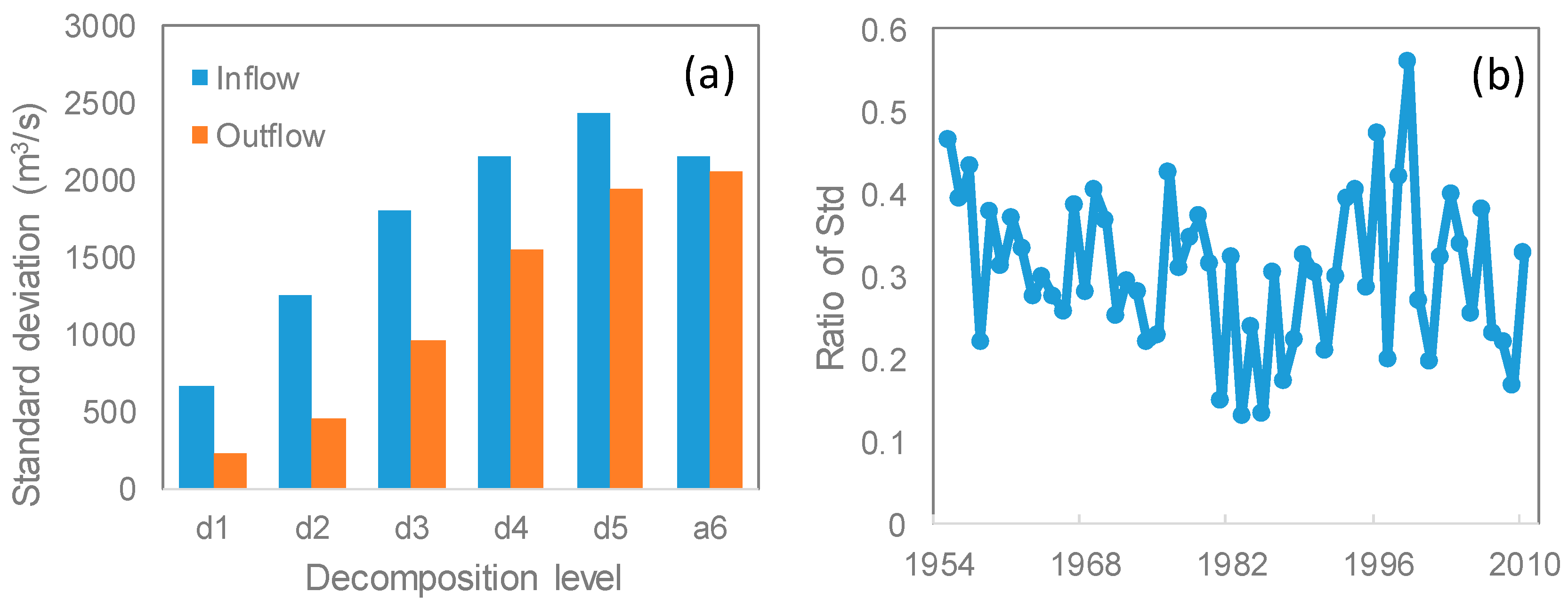
The wavelet decomposition of the inflows and the outflows of the lake reveals the differences in the variances of the respective wavelengths by the comparison of the standard deviation (Std). To reflect the regulation effects on floods of different timescales, the statistics on standard deviation of different decomposition levels are compared for inflow and outflow between 1955 and 2010 (Figure 3a). In general, the reduction effects on the fluctuation of inflows of the lake decrease with the increase of fluctuation duration. The lake is efficient in reducing the fluctuations in the runoff processes of durations less than 32 days (levels 1–5) from the comparison of the standard deviation (Std) of the wavelet decomposition between inflows and outflows. The removing amounts of level 1, level 2, and level 3 wavelet variances reach 437.6 m3/s, 797.4 m3/s, and 846.0 m3/s (66.7%, 64.2%, and 47.7%), respectively; this corresponds to time periods of 2 days, 4 days, and 8 days, respectively. The removing amount of a level 4 flood wave with a period of 16 days decreases to 602.9 m3/s (29.2%). The removing amount for a flood wave with a period of 32 days decreases to 486 m3/s (20.1%). The removing amount is up to 3170.1 m3/s (45.5%) on average for the runoff processes with durations less than 32 days.
Since the removing of fluctuations on inflows of the lake mainly functions on floods with durations less than 32 days (levels 1–5), the removing ratios of the standard deviation (Std) for the decompositions of levels 1–5 have been calculated year by year, from 1955 to 2010, to present the long-term evolution of the removing ratios of flood peaks. By means of a comparison of the changes in the standard deviation (Std) of inflow and outflow of the respective decomposition, the fluctuations removing ratios of the lake for medium- to small-scale flood peaks is calculated (Figure 3b), and indicates that the annual peak removing ratios for the inflows range from 0.13 to 0.56. Even though the flood peak removing ratios exhibit narrow ranges from year to year, its evolution does not show a significant tendency change in the long term. The highest value, 0.56, appears in 1998, which is correspondent to the devastative floods in the study regions. The ranges of the fluctuations in removing ratios for flood peaks shorter than medium-scale reveal the characteristics of the lake regulation, but the mechanism of the regulation capacity of the lake is more closely connected with the changes in maximum regulation volume.
3.3. Mechanism on the Regulation Capacity of the Lake
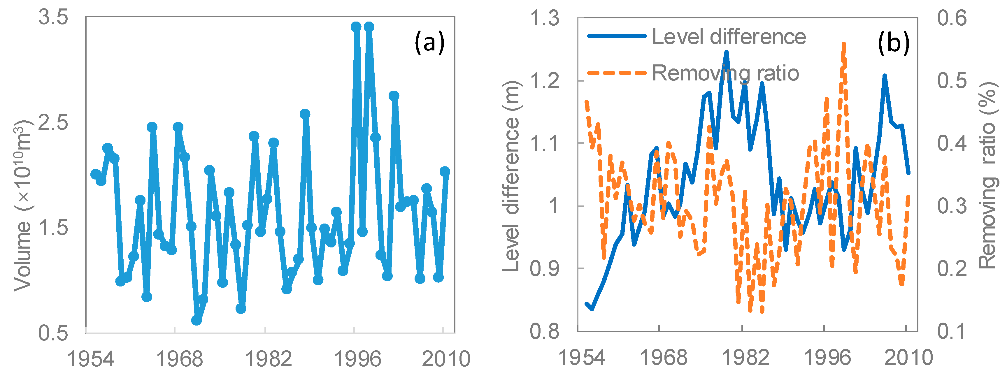
The maximum regulation volume of the lake is often decided by the systematic relationship of inflow discharge, real-time volume in lake, and discharge capability downstream of the outlet of the lake, which is used to reflect the essence changes in a flood regulation system. The maximum regulation volume of the lake each year is calculated based on the maximum inflow combined with the flood peak discharge and the corresponding outflow flood peak discharge (Figure 4a). The daily mean discharge of the largest flood peak of each year reduced by the lake ranges from 5.5 × 10⁸ m3 to 32.1 × 10⁸ m3, and the multi-year mean discharge of the largest flood peaks reduced by the lake is 14.6 × 10⁸ m3. In general, the annual maximum regulation volume does not exhibit a significant tendency of variation, which indicates that the changes in lake volume have not affected the maximum regulation capacity significantly.
In other words, during the study period, no systematic changes on the flood regulation effect happened. The regulation effect on flood of the lake is mainly decided by the characteristics of the inflow floods, or, to also say, that the inflow discharge peaks are still within extent of the flood that the lake could regulate. This judgement is also confirmed by the efficient removing ratio of the fluctuations for the most devastative floods in 1998. From this perspective, the flood regulation capacity of the Dongting Lake is a passive process, and is effective for most of the regional floods.
Flood regulation in lakes is largely different from the flood regulation in reservoirs, due to its free connection to the downstream rivers. The variation of the water level difference downstream from the outlet of the lake between Chenglingji and Luoshan (Figure 4b) exhibited a negative correlation with the trend of the flood peak reduction ratio of the lake over multiple years. Such a relation indicates that in the past decades, the discharge capacity downstream from the outlet of the lake is a decisive factor for the flood regulation capacity of the Dongting Lake.
Due to its large extent in space of the Dongting Lake, there are changes in water levels of different lake areas. The volume of the lake was calculated according to several flood control water levels around the lake. Since 1949, both area and volume have experienced big changes (Table 1). After 2003, the sediments in the lake have decreased significantly, thus the lake volume did not have big changes since then. However, by which means does this large volume reduction from sedimentation in the lake have not impacted the effect of the flood regulation capacity? The regulation effect on flood during the study period is characterized by the inflow floods, but its regulation processes are still decided by the discharge passing capacity within the complex river–lake system.
The discharge passing capacity, determined by the river–lake relationship downstream from the outlet, is one of the core factors that affects the flood regulation capacity of the lake. This dynamic can be changed both by the water level increase in the lake and the water level decrease in the river channel. The sediment is about 0.017 m/a within the lake [23,27], and about 10 billion m3 volume has been taken away since 1954. To cope with flood threats, the dikes around the lake have been heightened and strengthened continuously. Through these measures, the flood-controlling water level in the lake was increased. The record water level at the outlet of the lake was 33.95 m during the most serious flood in 1954, but it was recorded at 35.80 m for the less serious flood in 1998. The highest flood water level has increased about 1.9 m. This change largely increases the water level difference between the lake and mainstream of the Yangtze River, which in turn benefits the discharge passing capacity of the lake.
The large volume reduction caused by sedimentation in the lake is compensated by the increased flood controlling water level for the flood regulation capacity, but the increasing of flood controlling water level in the lake worsens the flood situation of areas connected with the lake, and has resulted in the new phenomenon of “normal discharge, high water level and disaster” in the lake regions after the 1990s [21,23]. As a result, it becomes more common that the water level exceeds the historical value with some normal flood events; that is to say, the lake kept its flood regulation capacity after the decrease in its area and volume, but exhibited some new effects in hydrology.
3.4. Impacts from the Operation of the Three Gorges Reservoir
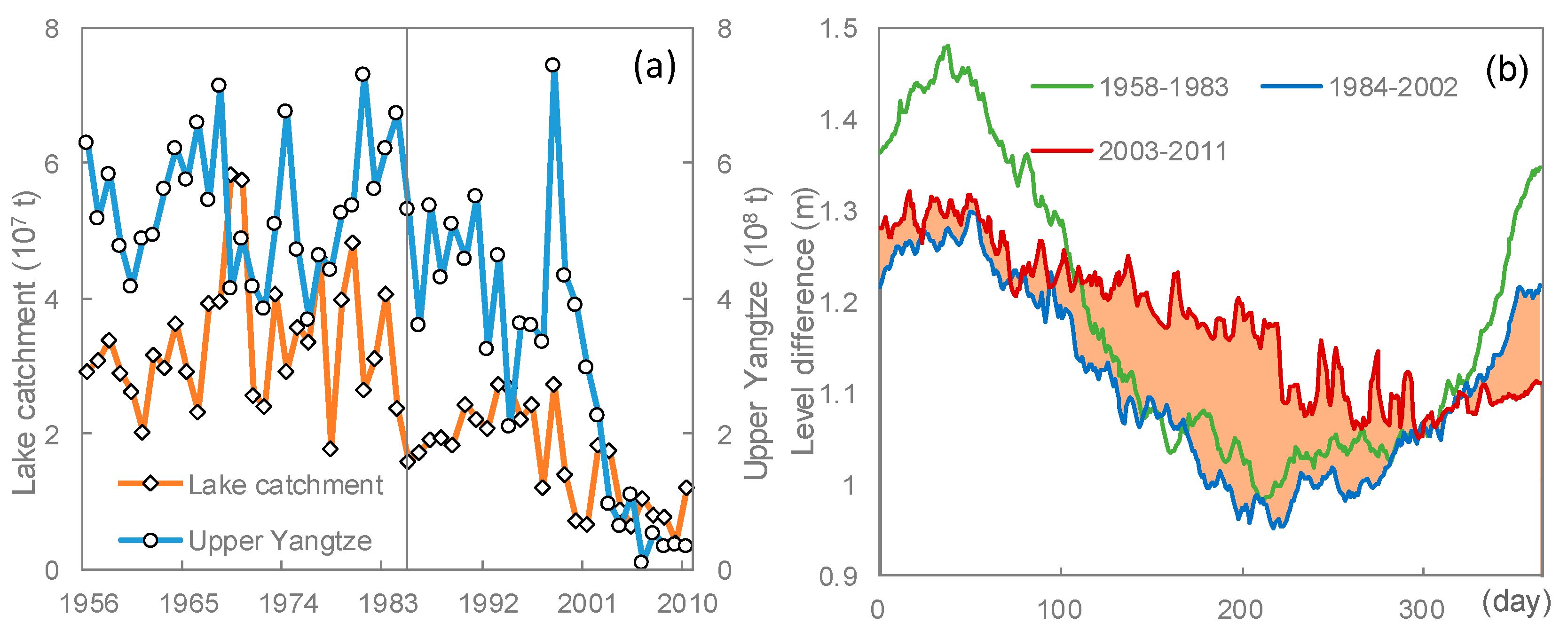
In view of its potential impacts on the flood regulation capacity, the lake–river relationship evolution caused by the operation of the Three Gorges Reservoir has attracted more attention. The long-term decrease of diversion ratio of water and sediment from the Yangtze River to the Dongting Lake is becoming the primary factor affecting the flood regulation capacity [15,21,44]. From Figure 5a, the sediment from the Dongting Lake catchment has start to decrease since 1983, and the sediment from the upper Yangtze has decreased since 2000. Both sources have come into an extremely low period after 2003, and the yearly average sediments decreased to 0.95 × 10⁷ m3 t and 0.55 × 10⁷ m3 t, respectively (62.7% and 88.7% compared with the average before 2003). As a result, the Dongting Lake, for the first time, has changed from trapping to supplying net sediment to the Yangtze River in 2006 [21]. According to the evaluation, the sediment load around the lake may reach a new balance in more than 50 years [45]. This will directly affect the water level difference downstream from the outlet of the lake.
Compared with the climate-induced droughts, the lake droughts caused by the dam operation often attract more concern [31,32,46]. The long-term evolution trend of the water level difference downstream from the outlet of the lake (Figure 5b) shows that the water difference downstream from the outlet of the lake is coming into a new stage since the operation of the Three Gorges Reservoir commenced in 2003. The significant impacts on the lake–river relationship by sediment reallocation from the operation of the Three Gorges Reservoir (TGR) alter the lake–river hydrological regimes. To measure this effect, the water level difference between the outlet of the lake at Chenglingji and the mainstream of Yangtze River at Luoshan has been calculated, based on the daily water level records, to reflect the discharge passing capacity downstream from the outlet of the lake (Figure 1). The water level difference has started to widen during the flood season (April–September), which increased about 0.15 m on average. A high water level difference means a better condition for fast water releasing from the lake. Thus, the discharge passing capacity downstream from the outlet of the lake is becoming a key factor that affects the flood regulation capacity. If this trend lasts, it will lead to a shift of the flood pressures from Dongting Lake to the downstream of Yangtze.
On the other hand, the water difference between flood season and the low water period becomes less significant. Especially, during the impound period after September, a decreased river flow has drastically decreased the diverted water from the Yangtze River to the Dongting Lake via the three inlets (Figure 1). As a result, a contemporary hydrological drought has arisen in the lake regularly [20,24]. The discharge passing capacity downstream from the outlet of the lake is becoming the core factor that affects the flood regulation capacity of the lake that may further boost the disputes on the construction of a dam for the lake.
4. Conclusions
The flood regulation function in a large retention lake is often a process for compound flood waves. The actual flood regulation characteristics of the lake, and their evolution, can be analyzed by using the wavelet decomposition based on the variances of the inflows and outflows of the lake. The Dongting Lake has a significant effect on reducing flood peaks, and the annual overall peak reduction ratios range from 0.13 to 0.56. The medium- to small-scale flood waves of less than 32 days are the main flood peaks reduced by the lake. The flood peak removing ratios and the maximum regulation volume show no significant tendency during the study period, although large volumes were reduced in the lake due to sedimentation and reclamation.
Among this lake–river system, the flood regulation capacity of the Dongting Lake is mainly determined by the combined effects of the increase of the flood control water level in the lake regions and the discharge passing capacity of the river channel downstream from the outlet of the lake. The changes in maximum regulation volume reveal that the flood regulation of the Dongting Lake exhibits a passive result of the interactions among different processes of discharge and sediment. The impact from the large volume reduction caused by sedimentation in the lake has been largely compensated by the increased flood controlling water level, which in turn has resulted in the new phenomenon of “normal discharge, high water level and disaster” in the lake regions after 1990s. In view of the significant impact on the lake–river relationship by sediment reallocation from the operation of the Three Gorges Reservoir, the discharge passing capacity downstream from the outlet of the lake is becoming a core factor that affects the flood regulation capacity. A new lake–river relationship benefiting the discharge capacity is forming, which may hint at a shift of the flood pressures from Dongting Lake to the downstream of Yangtze in the near future.
Author Contributions
Z.S. and Q.H. conducted the modeling, performed the analysis, and drafted the manuscript; Q.H. conceived of and designed the study and interpreted the results; Z.S. and T.L. assisted the field investigation and helped with the analysis. All the authors edited the manuscript. All authors have read and agreed to the published version of the manuscript.
Funding
This research was funded by the National Key Research and Development Program (2016YFA0602302, 2019YFA0607100), the Natural Science Foundation of China (41671028), strategic Priority Research Program of the Chinese Academy of Sciences (XDA23000000), and the Sino-German Scientific Center (GZ1213).
Conflicts of Interest
The authors declare no conflict of interest.
References
- Chaparro, G.; O’Farrell, I.; Hein, T. Multi-scale analysis of functional plankton diversity in floodplain wetlands: Effects of river regulation. Sci. Total Environ. 2019, 667, 338–347. [Google Scholar] [CrossRef] [PubMed]
- Gleick, P.H. Water management:Soft water paths. Nature 2002, 418, 373. [Google Scholar] [CrossRef] [PubMed]
- Coops, H.; Beklioglu, M.; Crisman, T.L. The role of water-level fluctuations in shallow lake ecosystems—Workshop conclusions. Hydrobiologia 2003, 506, 23–27. [Google Scholar] [CrossRef]
- Meeker, J.E.; Wilcox, D.A.; Harris, A.G. Changes in wetland vegetation in regulated lakes in Northern Minnesota, USA ten years after a new regulation plan was implemented. Wetlands 2018, 38, 437–449. [Google Scholar] [CrossRef]
- Heiler, G.; Hein, T.; Schiemer, F.; Bornette, G. Hydrological connectivity and flood pulses as the central aspects for the integrity of a river-floodplain system. Regul. Rivers Res. Manag. 1995, 11, 351–361. [Google Scholar] [CrossRef]
- Sondergaard, M.; Jeppesen, E.; Lauridsen, T.L.; Skov, C.; Van Nes, E.H.; Roijackers, R.; Lammens, E.; Portielje, R. Lake restoration: Successes, failures and long-term effects. J. Appl. Ecol. 2007, 44, 1095–1105. [Google Scholar] [CrossRef]
- Carmack, E.C.; Gray, C.B.J.; Pharo, C.H.; Daley, R.J. Importance of lake-river interaction on seasonal patterns in the general-circulation of Kamloops Lake, British-Columbia. Limnol. Oceanogr. 1979, 24, 634–644. [Google Scholar] [CrossRef]
- Almeida, R.M.; Hamilton, S.K.; Rosi, E.J.; Arantes, J.D.; Barros, N.; Boemer, G.; Gripp, A.; Huszar, V.L.M.; Junger, P.C.; Lima, M.; et al. Limnological effects of a large Amazonian run-of-river dam on the main river and drowned tributary valleys. Sci. Rep. 2019, 9, 16846. [Google Scholar] [CrossRef]
- Nakayama, T.; Shankman, D. Impact of the Three-Gorges Dam and water transfer project on Changjiang floods. Glob. Planet. Chang. 2013, 100, 38–50. [Google Scholar] [CrossRef]
- Pekel, J.F.; Cottam, A.; Gorelick, N.; Belward, A.S. High-resolution mapping of global surface water and its long-term changes. Nature 2016, 540, 418–422. [Google Scholar] [CrossRef]
- Sehgal, V.; Sahay, R.R.; Chatterjee, C. Effect of utilization of discrete wavelet components on flood forecasting performance of wavelet based ANFIS models. Water Resour. Manag. 2014, 28, 1733–1749. [Google Scholar] [CrossRef]
- Stanford, J.A.; Hauer, F.R. Mitigating the impacts of stream and lake regulation in the Flathead River Catchment, Montana, USA: An ecosystem perspective. Aquat. Conserv. 1992, 2, 35–63. [Google Scholar] [CrossRef]
- Smith, L.M.; Euliss, N.H.; Wilcox, D.A.; Brinson, M.M. Application of a geomorphic and temporal perspective to wetland management in North America. Wetlands 2008, 28, 563–577. [Google Scholar] [CrossRef]
- Opperman, J.J.; Galloway, G.E.; Fargione, J.; Mount, J.F.; Richter, B.D.; Secchi, S. Sustainable floodplains through large-scale reconnection to rivers. Science 2009, 326, 1487–1488. [Google Scholar] [CrossRef]
- Ou, C.M.; Li, J.B.; Zhou, Y.Q.; Cheng, W.Y.; Yang, Y.; Zhao, Z.H. Evolution characters of water exchange abilities between Dongting Lake and Yangtze River. J. Geogr. Sci. 2014, 24, 731–745. [Google Scholar] [CrossRef] [Green Version]
- Moisello, U.; Todeschini, S.; Vullo, F. The effects of water management on annual maximum floods of Lake Como and River Adda at Lecco (Italy). Civ. Eng. Environ. Syst. 2013, 30, 56–71. [Google Scholar] [CrossRef]
- Souter, N.J. Flood regime change in the Hattah Lakes Victoria resulting from regulation of the River Murray. Trans. R. Soc. S. Aust. 2005, 129, 74–80. [Google Scholar]
- Bedford, B.L.; Preston, E.M. Developing the scientific basis for assessing cumulative effects of wet land loss and degradation on landscape function: Status, perspectives, and prospects. Environ. Manag. 1988, 12, 751–772. [Google Scholar] [CrossRef]
- Chang, J.A.; Li, J.B.; Lu, D.Q.; Zhu, X.; Lu, C.Z.; Zhou, Y.Y.; Deng, C.X. The hydrological effect between Jingjiang River and Dongting Lake during the initial period of Three Gorges Project operation. J. Geogr. Sci. 2010, 20, 771–786. [Google Scholar] [CrossRef]
- Huang, Q.; Sun, Z.D.; Opp, C.; Lai, X.J.; Jiang, J.H. Hydrological drought at Dongting Lake: Its detection, characterization, and challenges associated with Three Gorges Dam in Central China. Water Resour. Manag. 2014, 28, 5377–5388. [Google Scholar] [CrossRef]
- Sun, Z.D.; Huang, Q.; Opp, C.; Hennig, T.; Marold, U. Impacts and implications of major changes caused by the Three Gorges Dam in the middle reaches of the Yangtze River, China. Water Resour. Manag. 2012, 26, 3367–3378. [Google Scholar] [CrossRef]
- Yin, H.F.; Liu, G.R.; Pi, J.G.; Chen, G.J.; Li, C.A. On the river-lake relationship of the middle Yangtze reaches. Geomorphology 2007, 85, 197–207. [Google Scholar] [CrossRef]
- Jiang, J.H.; Huang, Q. Imitative study on the effect of silts and cultivation on flooding in Dongting Lake. Resour. Environ. Yangtze Basin 2006, 5, 584–587. [Google Scholar]
- Zhang, J.H.; Huang, T.; Chen, L.; Liu, X.F.; Zhu, L.L.; Feng, L.J.; Yang, Y.P. Water-exchange response of downstream river-lake system to the flow regulation of the Three Gorges Reservoir, China. Water 2019, 11, 2394. [Google Scholar] [CrossRef] [Green Version]
- Church, M. Geomorphic response to river flow regulation: Case studies and time scales. Regul. Rivers Res. Manag. 1995, 11, 3–22. [Google Scholar] [CrossRef]
- Draut, A.E.; Logan, J.B.; Mastin, M.C. Channel evolution on the dammed Elwha River, Washington, USA. Geomorphology 2011, 127, 71–87. [Google Scholar] [CrossRef]
- Gao, J.F.; Zhan, C.; Jiang, J.H.; Huang, Q. Changes in sediment deposition and erosion and their spatial distribution in the Dongting Lake. Acta Geogr. Sin. 2001, 56, 269–277. [Google Scholar]
- Li, Y.; Deng, J.; Sun, Z.; He, Y. A study on flood storage capacity in Dongting Lake. J. Sediment Res. 2001, 6, 1–7. [Google Scholar]
- Labat, D.; Godderis, Y.; Probst, J.L.; Guyot, J.L. Evidence for global runoff increase related to climate warming. Adv. Water Resour. 2004, 27, 631–642. [Google Scholar] [CrossRef]
- Monsen, N.E.; Cloern, J.E.; Monismith, L.S.G. A comment on the use of flushing time, residence time, and age as transport time scales. Limnol. Oceanogr. 2002, 47, 1545–1553. [Google Scholar] [CrossRef] [Green Version]
- Kepa, B.M.; Sardelic, D.N.; Waretini, A.F. The Three Gorges Project: How sustainable? J. Hydrol. 2012, 460–461, 1–12. [Google Scholar] [CrossRef]
- Jiao, L. Scientists line up against dam that would alter protected wetlands. Science 2009, 326, 508–509. [Google Scholar] [CrossRef] [PubMed]
- Sun, Z.; Groll, M.; Opp, C. Lake-catchment interactions and their responses to hydrological extremes. Quatern. Int. 2018, 475, 1–3. [Google Scholar] [CrossRef]
- Reckendorfer, W.; Baranyi, C.; Funk, A.; Schiemer, F. Floodplain restoration by reinforcing hydrological connectivity: Expected effects on aquatic mollusc communities. J. Appl. Ecol. 2006, 43, 474–484. [Google Scholar] [CrossRef]
- Gupta, V.K.; Mesa, O.J.; Dawdy, D.R. Multiscaling theory of flood peaks: Regional quantile analysis. Water Resour. Res. 1994, 30, 3405–3421. [Google Scholar] [CrossRef]
- Bloschl, G.; Sivapalan, M. Scale issues in hydrological modeling—A review. Hydrol. Process. 1995, 9, 251–290. [Google Scholar] [CrossRef]
- Chakraborty, A.; Okaya, D. Frequency-time decomposition of seismic data using wavelet-based methods. Geophisics 1995, 60, 1906–1916. [Google Scholar] [CrossRef] [Green Version]
- Morlet, J.; Arens, G.; Fourgeau, E.; Giard, D. Wave-propagation and sampling theory—Part II: Sampling theory and complex waves. Geophysics 1982, 47, 222–236. [Google Scholar] [CrossRef]
- Bradshaw, G.A.; McIntosh, B.A. Detecting climate-induced patterns using wavelet analysis. Environ. Pollut. 1994, 83, 135–142. [Google Scholar] [CrossRef]
- Zhao, S.; Fang, J.; Miao, S.; Gu, B.; Tao, S.; Peng, C.; Tang, Z. The 7-decade degradation of a large freshwater lake in central Yangtze river, China. Environ. Sci. Technol. 2005, 39, 431–436. [Google Scholar] [CrossRef]
- Shen, G.Z.; Xie, Z.Q. Three Gorges Project: Chance and challenge. Science 2004, 304, 681. [Google Scholar] [CrossRef] [Green Version]
- Campozano, L.; Mendoza, D.; Mosquera, G.; Kenneth, P.; Rolando, C.; Crespo, P. Wavelet analyses of neural networks based river discharge decomposition. Hydrol. Process. 2020, 34, 2302–2312. [Google Scholar] [CrossRef]
- Debnath, L. Wavelet transforms and time-frequency signal analysis. Technometrics 2000, 44, 87. [Google Scholar]
- Dai, S.B.; Lu, X.X. Sediment deposition and erosion during the extreme flood events in the middle and lower reaches of the Yangtze River. Quatern. Int. 2010, 226, 4–11. [Google Scholar] [CrossRef]
- Yang, Z.; Wang, H.; Saito, Y.; Milliman, J.D.; Xu, K.; Qiao, S.; Shi, G. Dam impacts on the Changjiang (Yangtze) River sediment discharge to the sea: The past 55 years and after the Three Gorges Dam. Water Resour. Res. 2006, 42, L10401. [Google Scholar] [CrossRef]
- Van Lanen, H.A.J.; Wanders, N.; Tallaksen, L.M.; Van Lanen, A.F. Hydrological drought across the world: Impact of climate and physical catchment structure. Hydrol. Earth Syst. Sci. 2013, 17, 1715–1732. [Google Scholar] [CrossRef] [Green Version]
Figure 1.
Lake basin, complex hydrological networks, lake–river relationship, and gauging stations in the Dongting Lake region.
Figure 1.
Lake basin, complex hydrological networks, lake–river relationship, and gauging stations in the Dongting Lake region.

Figure 2.
The wavelet decomposition of different frequency fluctuations for inflow and outflow of the lake. S is the original flow series, d1 to d5, and a5 represents the decomposition of 2, 4, 8, 16, 32, and 64 days.
Figure 2.
The wavelet decomposition of different frequency fluctuations for inflow and outflow of the lake. S is the original flow series, d1 to d5, and a5 represents the decomposition of 2, 4, 8, 16, 32, and 64 days.

Figure 3.
Comparison of the standard deviation (Std) of the wavelet decomposition between inflows and outflows (a), and the removing ratios of the Std for medium- to small-scale flood (b).
Figure 3.
Comparison of the standard deviation (Std) of the wavelet decomposition between inflows and outflows (a), and the removing ratios of the Std for medium- to small-scale flood (b).

Figure 4.
Dynamics of the maximum flood regulation volume (a), and relationship between the flood peak reduction ratio and the water level difference downstream of the lake (b).
Figure 4.
Dynamics of the maximum flood regulation volume (a), and relationship between the flood peak reduction ratio and the water level difference downstream of the lake (b).

Figure 5.
The changes of sediment transport from the lake catchment and the Upper Yangtze (a), and long-term evolution trend of the water level difference downstream the outlet of the lake (b).
Figure 5.
The changes of sediment transport from the lake catchment and the Upper Yangtze (a), and long-term evolution trend of the water level difference downstream the outlet of the lake (b).


Table 1.
The area and volume evolution of the lake.
| Year | 1949 | 1954 | 1958 | 1971 | 1977 | 1984 | 1995 |
|---|---|---|---|---|---|---|---|
| Area (km2) | 4350 | 3915 | 3141 | 2820 | 2740 | 2691 | 2625 |
| Volume (108 m3) | 293 | 268 | 228 | 188 | 178 | 174 | 167 |
The data were corresponding to the water level of 33.50 m at the lake outlet.
© 2020 by the authors. Licensee MDPI, Basel, Switzerland. This article is an open access article distributed under the terms and conditions of the Creative Commons Attribution (CC BY) license (http://creativecommons.org/licenses/by/4.0/).
Share and Cite
MDPI and ACS Style
Sun, Z.; Huang, Q.; Lotz, T. Evolution of Flood Regulation Capacity for a Large Shallow Retention Lake: Characterization, Mechanism, and Impacts. Water 2020, 12, 2853. https://doi.org/10.3390/w12102853
AMA Style
Sun Z, Huang Q, Lotz T. Evolution of Flood Regulation Capacity for a Large Shallow Retention Lake: Characterization, Mechanism, and Impacts. Water. 2020; 12(10):2853. https://doi.org/10.3390/w12102853
Chicago/Turabian StyleSun, Zhandong, Qun Huang, and Tom Lotz. 2020. "Evolution of Flood Regulation Capacity for a Large Shallow Retention Lake: Characterization, Mechanism, and Impacts" Water 12, no. 10: 2853. https://doi.org/10.3390/w12102853
Note that from the first issue of 2016, this journal uses article numbers instead of page numbers. See further details here.